
1800-1899 Date Range County Map Antique Europe Folding Maps
98 results
c1880 SOMERSET Cruchley's County Maps of England For Cyclists Tourists Etc..
£10.00£2.95 postageStanford's Cloth Map 22x15 inch of the county of LONDON of 1888 Old Folding Maps
£3.000 bids£2.99 postageEnding 19 May at 7:34PM BST8d 16hJAMES WYLD Antique 6 inches : 1 mile CLOTH MAP OF Ford, Shropshire
£40.000 bidsFree postageEnding Sunday at 9:12PM BST1d 18hJAMES WYLD WYLD’s ANTIQUE CLOTH MAP OF STAFFORD 1891 19th CENTURY SCARCE
£46.54£4.95 postageDurham & Northumberland Large John Cary Maps, 1821 Census, Town Distances
£150.00Free postageWalker's DEVONSHIRE, antique folding map, J & C Walker circa 1840s, Devon
£39.99£1.29 postage19th Century Map of Northamptonshire Edward Stanford HAND COLOURED Ordnance
£20.00£4.35 postageCruchley's county map of Kent for cyclists and tourists1896
£14.99£3.50 postageA New Map Of The County Of Suffolk Divided Into Hundreds by Thos. Dix c1830
£60.000 bidsEnding Sunday at 6:00PM BST1d 14hFree postageDugdales Framed Engraved Map of North Riding of Yorkshire c1846
£12.990 bidsEnding Sunday at 3:08PM BST1d 11h£7.00 postageAntique 1801? FOLDING MAP ON A CLOTH A NEW MAP OF MIDDLESEX JOHN CARY
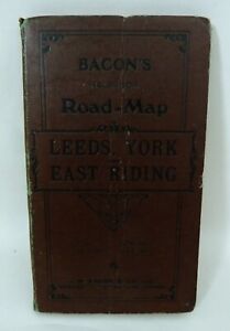
£200.00£5.50 postageBacon's Leeds York and East Riding Half Inch Road Map antique 70 x 100 cms
£15.00£3.25 postageSURREY C.W. Deacon original antique railway map c1880
£55.00Free postage1839 Antique MAP OF THE STATES OF ITALY Corsica Sardinia by WYLD Folded On Cloth
£75.000 bidsEnding Sunday at 7:48PM BST1d 16h£2.70 postageVintage Map of Lands End and Cornwall (c1890) W H Smith, Bartholomew - Cloth Map
£24.99£375.00 postagec1830 MAP Somersetshire Divided into Hundreds &c and the Parliamentary Divisions
£115.00£4.35 postageAntique Map "Huntingdonshire" J & C Walker, 1846
£50.00£7.00 postageOS Maps Robert Dawson Collection of County Maps
£99.00£3.99 postage1810 MAP Ordnance Survey of the Isle of Wight And part of Hampshire LARGE FORMAT
£165.00£4.35 postageAntique Map "Buckinghamshire" J & C Walker, 1845
£45.00£7.00 postagec1820 MAP Cornwall From a recent Survey With the Railways SCARCE ORIGINAL Linen
£200.00£4.35 postage1800 Denbigh and Flint 1895 Antique County Map 10x12.5"
£35.96£16.52 postage1800's Dorsetshire England 1895 Antique County Map 10 x 12.5"
£35.96£16.52 postage1800s Devonshire England 1895 Antique County Map 10 x 12.5"
£35.96£16.52 postage1800's Cheshire 1895 Antique County Map 10 1/4 x 10 1/2"
£35.96£16.52 postageAntique Map "Gloucestershire" J & C Walker, 1845
£50.00£7.00 postagec1850 Wyld Kent Reduced Ordnance Survey Faden Mudge Large 96x65cms Antique Map
£175.00£7.00 postageAntique Map "Worcestershire" J & C Walker, 1846
£50.00£7.00 postageAntique Map "Northamptonshire" J & C Walker, 1835
£50.00£7.00 postageBacon’s New Tourist Map of South Wales Names of Railway Stations ca1890
£33.00Free postage1800s Derbyshire England 1895 Antique County Map 10x12.5"
£39.96£16.64 postage1800s Cumberland England 1895 Antique County Map of 10x12.5"
£35.96£16.52 postageFaden The Country Twenty-Five Miles Round London Slipcase Hand Coloured 1815
£765.00Free postageDavid and Charles 1970 reprint map of Cirencester area 1800's
£3.80£0.99 postagec1880 Bacon's County Guide and Map of Cheshire - Coloured Cloth
£20.00£2.95 postage1804 (1827) Antique Folding Map; Nottinghamshire. Charles Smith - Excellent
£69.99£3.90 postage1840s Staffordshire County Folding Map. Pub by H G Collins. Original Colour
£39.99£2.00 postage1804 (1821) Antique Folding Map; Herefordshire. Charles Smith - Excellent
£69.99£3.90 postageantiquarian Map Rutland Shire - 1845
£10.990 bidsEnding Sunday at 4:14PM BST1d 13h£3.99 postageAntique Folding Map, Walker, J & C, Northamptonshire c1840
£39.95Free postageGeorge Philip Cyclists map the county of lancashire
£40.00£1.50 postageBacon's County Map of Northumberland c1880-90's Fold-out Linen
£24.99Free postage1874 V. Large MAP North of England With County of Durham 146cm x 131cm SCARCE
£600.00£4.35 postage1804 (1825) Antique Folding Map; Oxfordshire. Charles Smith - Excellent
£89.99£3.90 postage1804 (1825) Antique Folding Map; Wiltshire. Charles Smith. Excellent Example
£89.99£3.90 postage1835 Antique Map of Buckinghamshire by J & C. Walker
£24.99£3.90 postage


You may also like
1800-1899 Date Range County Map Wall Antique European Maps & Atlases
1800-1899 Date Range City Map Antique Europe Folding Maps
1900-1909 Date Range County Map Antique Europe Folding Maps
1930-1939 Date Range County Map Antique Europe Folding Maps
1920-1929 Date Range County Map Antique Europe Folding Maps


Deals for you
Grab a further 10% with code BLUEBELL10Shop nowMin spend £9.99. Max discount £75.T&Cs apply.

![Ninja Foodi FlexDrawer Air Fryer - Certified Refurbished [AF500UK] 10.4L](https://i.ebayimg.com/thumbs/images/g/j3EAAOSwtGpmPiFA/s-l225.jpg)


