Antique Europe Folding Maps
Shop by Original/Reproduction


Shop by Date Range
4,241 results
City of London Street Plan
£6.001 bidFree postageEnding Friday at 7:18PM BST22h 38mJohn Cary hand coloured map of LANCASHIRE Dated 1818
£56.000 bids£2.40 postageEnding Today at 8:41PM BST1m 28sAntique Topographical map of London
£20.000 bidsFree postageEnding 13 May at 3:04PM BST3d 18hJohn Cary hand coloured map of SOMERSET (shire) Dated 1818
£58.000 bids£2.40 postageEnding Today at 8:45PM BST5m 28sANTIQUE EDWARD STANFORD LINEN ORDNANCE SURVEY MAP LYDNEY PARK EST. GLOS.
£14.990 bids£2.70 postageEnding Friday at 3:09PM BST18h 30mFolding Ordnance Survey Map Ripon & Area 119. Hand Coloured - 1848-1856
£69.00£3.65 postageANTIQUE LEATHER CASED MAPS (40). 1923. PUBLISHED by MINISTRY OF TRANSPORT
£105.00£7.50 postage6 Vintage 1950s BMC County Road Map And Gazetteer No 18,14,29,30,28,30
£14.990 bidsFree postageEnding 13 May at 8:00PM BST3d 23hRare Georgian Antique Panoramic Illustrated Map The Alps & Lake Geneva
£35.000 bids£2.65 postageEnding 14 May at 6:38PM BST4d 21hOrdnance Survey one inch map of North Staffordshire. 1930
£4.500 bids£2.30 postageEnding 15 May at 7:39PM BST5d 22hOrdnance Survey one inch map of Norwich. Sheet 67. 1910
£4.950 bids£1.90 postageEnding 15 May at 7:47PM BST5d 23hGall & Inglis Map And Guide To London Five Inch To Mile 1890?
£30.006 bids£3.00 postageEnding Sunday at 4:08PM BST2d 19hBowles Reduced Pocket Plan London to Year 1799
£19.990 bidsEnding 15 May at 3:03PM BST5d 18h£4.99 postageOrdnance Survey one inch map of Manchester District. 1924.
£4.600 bids£2.30 postageEnding 15 May at 7:35PM BST5d 22hOrdnance Survey of Scotland Sheet 33 part of Sheet 41 HADDINGTON 1909
£12.00Free postageWYLD’S NEW MAP 0F LONDON 1870 - LINEN BACKED
£250.00£7.50 postageBacon's New Large Print Map of London and Suburbs - Circa 1914
£28.00£2.95 postageOrdnance Survey one inch special map of Forest of Bowland. 1934.
£3.600 bids£2.30 postageEnding 15 May at 7:36PM BST5d 22hOrdnance Survey Map - Vintage - Shrewsbury
£10.000 bids£2.30 postageEnding Friday at 2:27PM BST17h 48mLondon Underground Stingemore Tube maps(2)
£145.000 bids£1.55 postageEnding 14 May at 10:53AM BST4d 14h8 x Antique RAF Charts
£10.001 bidFree postageEnding Saturday at 3:15PM BST1d 18h1921 Original Europe European American Express Map Travel Guide Standford London
£7.960 bidsEnding Today at 9:07PM BST28m 21s£13.53 postage2 Original Vintage Maps OF USSR, 1 Political And 1 Geographical 1977 And 1978
£5.991 bid£2.94 postageEnding Friday at 9:51AM BST13h 11mOrdnance Survey Scotland half inch map of Inverness & Nairn, Sheet 13, 1912
£3.000 bids£1.90 postageEnding 16 May at 6:37PM BST6d 21hOrdnance Survey one inch District map of Southampton. 1928.
£5.082 bids£1.80 postageEnding 15 May at 7:33PM BST5d 22h1646 COLOUR MAP OF EAST RIDING YORKSHIRE JANSSON EBORACENSIS PARS ORIENTALIS *
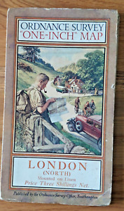
£79.990 bids£6.00 postageEnding Sunday at 7:09PM BST2d 22hOrdnance Survey one inch District map of London (North). 1925.
£4.601 bid£2.30 postageEnding 15 May at 7:37PM BST5d 22hRARE 1930’s VINTAGE CROYDON LONDON - COLOGNE 9’ AVIATION MAP EDWARD STANFORD LTD
£11.503 bids£3.20 postageEnding 15 May at 8:30PM BST5d 23hVintage Blakes Map Of The Norfolk Broads For Cruising And Sailing
£4.990 bids£2.50 postageEnding 13 May at 8:15PM BST3d 23h10 X MICHELIN CARTE A ROAD MAPS OF FRANCE, LOT 4
£9.99Free postageTopographical Maps Of Canterbury Set Of 5( ARCHAEOLOGICAL TRUST)
£7.50£3.50 postageVintage Cyclists Cycling Maps of Northampton
£3.000 bids£2.50 postageEnding Saturday at 7:00PM BST1d 22hOrdnance Survey Map - Vintage - Huntingdon
£10.000 bids£1.70 postageEnding 14 May at 12:24PM BST4d 15hOrdnance Survey half inch training map Harrogate, Leeds, Bradford Sheet 9. 1912
£6.502 bids£1.80 postageEnding 15 May at 6:34PM BST5d 21hOrdnance Survey one inch map of Whitby & Saltburn. Sheet 16. 1907
£3.951 bid£2.20 postageEnding 15 May at 7:41PM BST5d 23h1919 Seed's MAP of SOUTHPORT AND BIRKDALE Very Scarce Preston Printed Street Map
£55.000 bids£3.50 postageEnding Friday at 1:25PM BST16h 46mOrdnance Survey one inch map of Buckingham. Sheet 96. 1907
£4.950 bids£1.90 postageEnding 15 May at 7:49PM BST5d 23hVintage map of St Helens offers invited
£5.000 bidsEnding Today at 9:28PM BST48m 57s£1.00 postageVINTAGE LINEN WARD LOCK MOTORING MAP SHEET 19 - LONDON & SUSEX COAST
£5.00£3.95 postageOrdnance Survey 1" Third Edition District Map of Dorking and Leith Hill District
£8.000 bidsEnding Sunday at 6:30PM BST2d 21h£1.55 postageThe Authentic Map of London
£20.000 bidsEnding 13 May at 10:29PM BST4d 1h£2.70 postageOrdnance Survey one inch District map of Wye Valley. 1929.
£4.201 bid£1.80 postageEnding 15 May at 7:31PM BST5d 22hOrdnance Survey half inch layered map of Harrogate & Bradford, Sheet 9, 1912
£4.750 bids£1.90 postageEnding 15 May at 6:37PM BST5d 21h33 Vintage Bartholomew's Half-inch Maps Cloth & Paper 1945-1961 Bundle
£40.00Free postagecirca 1930s LARGE linen Backed GLASGOW STREET MAP Scotland Scottish History
£55.000 bids£4.19 postageEnding Friday at 12:56PM BST16h 16mVintage Europa BP Map Touring Service Fold Out Paper Ephemera Travel
£6.49£2.99 postage1794 Country Around Manchester Large Folding Map by Stockdale 84 cm x 81 cm
£175.00£2.00 postage🌟Antique Framed Robert Morden - Oxfordshire map circa 1722 "Frame 54cm X 62cm🌟
£99.99£12.99 postage