


Find Your Way into Collecting Antique Ordnance Survey Maps
With a history stretching back to the 18th century, the Ordnance Survey has been producing excellent maps for hundreds of years. Collecting old Ordnance Survey maps can be both intriguing and rewarding. There's a huge range including many Ordnance Survey tourist maps for early motorists. You'll find a wide selection of inexpensive, old Ordnance Survey maps for sale on eBay, so take a little time to navigate the listings.
How can you tell which edition is listed?The date you see on an eBay listing is likely to be the last revision of the map in question. If you're specifically looking for a first edition, it's worth checking for that term, either in the listing or on accompanying photos. Some antique Ordnance Survey maps for sale on eBay may be reprints of earlier editions, so make sure you ask if you're not sure. Pictures of a map's cover are useful in assessing its condition.
Wartime OS maps can be intriguing optionsDuring both World Wars, the Ordnance Survey was vital to the war effort, producing a variety of maps that are now highly collectable. Many of the maps produced between 1914 and 1918 show parts of France and Belgium, while those created in the Second World War cover some more far-flung areas. Survey maps from the era include one of Italy and another of South Africa. You'll also find antique maps of parts of Britain, sometimes with overlays showing things, such as airfields and electricity distribution networks.
What should you watch for with County Series maps?The classic County Series, produced in the 19th century but maintained until the 1940s covers the whole of Great Britain at large scale. With these antique Ordnance maps, check:
- Scale: The whole country is covered at six-inch scale (1:10,560) but some areas are at 25-inch scale (1:2,500).
- Restricted sheets: Some later County Series maps were made for government departments and showed sensitive installations, such as dockyards.
- Revisions: The second and third editions of these maps may be listed as "first revision" and "second revision".
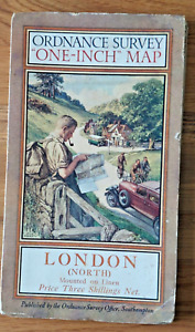
Ordnance Survey maps were scaled in imperial measurements from their inception until the second half of the 20th century, with those at a scale of one inch to one mile being very widely used. You can recognise these by their red and cream covers, and their publication and revision date either side of the small reference map on the front. From the 1970s onwards, OS maps became metricated, although early 1:50,000 maps didn't bear the later Landranger branding. Extremely large-scale maps sometimes used both scales, so you'll find both 1:500 and 1:528 scale, the latter known as "ten-foot" as that was equivalent to one mile.