
Antique Europe Maps & Atlases
Shop by Date Range
127,322 results
1900 Muswell Hill Crouch End Highgate Hornsey Antique London Street Plan
£24.99£2.00 postageVintage Admiralty Charts 1960s-1980’s
£7.50£7.00 postage"Chester Orderaround" A3 Pub Map Poster
£12.50Free postage"Whitby Orderaround" A3 Pub Map Poster
£13.00Free postageOld map Environs of Windsor, Berkshire 1898
£15.99£4.00 postage"Barnsley Town Orderaround" A3 Pub Map poster
£12.50Free postageNew listingLONDON HAMMERSMITH EARLS CT S KENSINGTON ANTIQUE BARTHOLOMEWS MAP c1950 11"x9"
£11.990 bidsEnding Sunday at 9:42PM BST6d 16h£1.50 postageMiddlesbrough , old map Yorkshire 1920: 6 SW antiqued
£23.99£4.00 postage"Rotherham Orderaround" A3 Pub Map Poster
£12.50Free postageNew listingLONDON BUCKINHAM PALACE PIMLICO GREEN PK ANTIQUE BARTHOLOMEWS MAP c1920 6"x9"
£9.990 bidsEnding Sunday at 9:42PM BST6d 16h£1.50 postageOriginal Antique Map Print Exeter, Devon - by Mutlow 1800 Around 200 Years Old.
£200.00£10.00 postage11 watching1900 Stratford Leytonstone Forest Gate Antique London Street Plan
£24.99£2.00 postageantique map hemisphae alis coeli map globe map earth
£19.99£3.99 postageNew listingLONDON ISLE OF DOGS POPLAR PLAISTOW VINTAGE STREET MAP 1948 PHILIPS ABC 10x8"
£9.990 bidsEnding Sunday at 9:42PM BST6d 16h£1.50 postageNew listingRICHMOND TWICKENHAM VINTAGE LONDON STREET MAP 1948 KINGSTON PHILIPS ABC 10x8"
£9.990 bidsEnding Sunday at 9:42PM BST6d 16h£1.50 postageNew listingOrdnance survey reprint of first edition map - Louth & Patrington
£2.990 bids£1.15 postageEnding Sunday at 3:12PM BST6d 10hNew listingLONDON TWICKENHAM RICHMOND ISLEWORTH ANTIQUE BARTHOLOMEWS MAP c1950 11"x9"
£11.990 bidsEnding Sunday at 9:42PM BST6d 16h£1.50 postageNew listing1610 MERCATOR MAP HOLLAND UTRECHT RARE ORIGINAL COLOUR TEXT VERSO 22cmx18cm
£39.990 bidsEnding Sunday at 9:42PM BST6d 16h£3.00 postageBarnsley E, Cudworth, Grimethorpe, old map Yorkshire 1938: 275NW repro
£18.99£4.00 postageJack the Ripper Locations Map - Whitechapel, London 1888
£21.99£4.00 postage110 soldPoole Parkstone, Longfleet, St Aldhelms, old map Dorset 1902: 44SW
£18.99£4.00 postageNew listingHistorical Map Of Scotland LG Bullock John Bartholomew And Son
£4.000 bidsEnding Friday at 7:00PM BST4d 13h£2.50 postageIRELAND, KINGDOM OF, 1610 by J. Speed - reproduction old map - fits A2 frame
£20.99£4.00 postagec1895 Map of Central London England antique vintage Britannica 9th
£6.50£2.50 postageOld map of Kent - Framed - Antique ?
£115.00£12.95 postageAntique 17th Century Map of Hampshire by Robert Morden
£78.03£6.50 postagePalestine Tatreez Pattern Mug
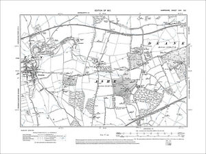
£12.00£3.00 postageOverton, Ashe, Dean, Old Map Hampshire 1912: 17SE
£18.99£4.00 postageRiver Thames Old London Bridge Elizabethan view map Merian 1638 art poster print
£20.50£7.50 postage20 watchingSOUTHWOLD borough/town plan. BOUNDARY COMMISSION. Suffolk. DAWSON 1837 map
£25.00£5.00 postageEUROPE. European. General Map; Inset map of Population map 1907 old
£10.00£5.00 postageOld map Environs of Wigan, Lancashire - 1898
£15.99£4.00 postageOld map Environs of Stoke on Trent, Longton, Hanley, Staffordshire - 1898
£15.99£4.00 postage100% ORIGINAL LARGE NORTHAMPTONSHIRE MAP BY J BLAEU in 1646 ANTIQUE PRINT
£250.00£10.00 postageVINTAGE W AK JOHNSTON 1950s SCHOOL EDUCATIONAL ENGLAND & WALES COUNTIES WALL MAP
£110.00£12.95 postageHEREFORD Street Plan / Map of the Town - Vintage Folding Map 1938
£5.99£0.99 postageHoughton Conquest, old map Bedfordshire 1901: 21NE
£18.99£4.00 postageBattle of Waterloo plan 2 A K Johnston map Alison's Atlas 1850 art print poster
£18.90£7.50 postage7 watchingBIRMINGHAM CITY CENTRE antique town plan. BAEDEKER 1910 old map chart
£8.00£4.00 postageSpitsbergen Archipelago. Svalbard Norway arctic. Sketch map 1885 old
£12.99£4.00 postageImber, old map Wiltshire 1926: 45SE repro
£18.99£4.00 postageNew listingMAP OF NOTTINGHAMSHIRE, ORIGINAL THOMAS CONDER, C. 1784, HAND COLOURED
£6.990 bids£2.70 postageEnding Sunday at 3:56PM BST6d 10hOld map Environs of Middlesbrough, North Yorkshire -1898
£15.99£4.00 postageChulmleigh, Bridge Reeve, Old Map Devon 1906: 42NE
£18.99£4.00 postageRyde, Binstead, Swanmore, Old Map Hampshire Isle Of Wight 1909: 91SW
£18.99£4.00 postageCaledonian Railway - Grangemouth Docks (85 X 39cm)
£15.00Free postageantique Tombleson's map of river Thames with 9 inset views 1850 art print poster
£28.70£7.50 postage17 watchingNew listingStilton to Tuxford Road Map, Thomas Gardner 1719 Original Stamford Grantham
£65.000 bidsFree postageEnding Sunday at 8:01PM BST6d 14hOld map Folkestone (N), Hawkinge, Arpinge OS Kent 75-NW-1938 A2
£17.99£4.00 postageNortham - old Devon map 12-14-1932
£19.99£4.00 postageNew listingOrdnance Survey 1" Third Edition District Map of Dorking and Leith Hill District
£8.000 bidsEnding Sunday at 6:39PM BST6d 13h£1.55 postage1794 Country Around Manchester Large Folding Map by Stockdale 84 cm x 81 cm
£175.00£2.00 postageantique geological map England Wales R Murchison 1842 British geology art poster
£18.90£7.50 postage111 sold


You may also like


Deals for you
Grab a further 10% with code BLUEBELL10Shop nowMin spend £9.99. Max discount £75.T&Cs apply.

![Ninja Foodi FlexDrawer Air Fryer - Certified Refurbished [AF500UK] 10.4L](https://i.ebayimg.com/thumbs/images/g/j3EAAOSwtGpmPiFA/s-l225.jpg)


