
Antique Europe Maps & Atlases
Shop by Date Range
127,290 results
Vintage Admiralty Charts 1960s-1980’s
£7.50£7.00 postage"Chester Orderaround" A3 Pub Map Poster
£12.50Free postageNew listingEsso Road Map No 8 Ireland Vintage
£5.00£2.70 postageNew listingEsso Road Map No 2 South And East England Vintage
£5.00£2.70 postageNew listingEsso Road Map No 6 Southern Scotland Vintage
£5.00£2.70 postageNew listingOS Map One-Inch 1947, Sheet 142: Hereford, on paper
£5.00£2.70 postage1900 Muswell Hill Crouch End Highgate Hornsey Antique London Street Plan
£24.99£2.00 postage"Whitby Orderaround" A3 Pub Map Poster
£13.00Free postage"Barnsley Town Orderaround" A3 Pub Map poster
£12.50Free postageNew listingOS Map One-Inch 1964, Sheet 187: Plymouth, on paper
£5.00£2.70 postageOld map Environs of Windsor, Berkshire 1898
£15.99£4.00 postageJack the Ripper Locations Map - Whitechapel, London 1888
£21.99£4.00 postage110 soldNew listingOS Map One-Inch 1967, Sheet 158: Oxford & Newbury, on paper
£5.00£2.70 postageNew listingOS Map One-Inch 1969, Sheet 107: Snowdon, on paper
£5.00£2.70 postageMiddlesbrough , old map Yorkshire 1920: 6 SW antiqued
£23.99£4.00 postage"Rotherham Orderaround" A3 Pub Map Poster
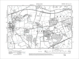
£12.50Free postageOverton, Ashe, Dean, Old Map Hampshire 1912: 17SE
£18.99£4.00 postageOld map Environs of Stoke on Trent, Longton, Hanley, Staffordshire - 1898
£15.99£4.00 postageOriginal Antique Map Print Exeter, Devon - by Mutlow 1800 Around 200 Years Old.
£200.00£10.00 postage11 watchingc1895 Map of Central London England antique vintage Britannica 9th
£6.50£2.50 postageAntique 17th Century Map of Hampshire by Robert Morden
£78.03£6.50 postage100% ORIGINAL LARGE NORTHAMPTONSHIRE MAP BY J BLAEU in 1646 ANTIQUE PRINT
£250.00£10.00 postagePoole Parkstone, Longfleet, St Aldhelms, old map Dorset 1902: 44SW
£18.99£4.00 postageHoughton Conquest, old map Bedfordshire 1901: 21NE
£18.99£4.00 postageOld map Environs of Wigan, Lancashire - 1898
£15.99£4.00 postageSHROPSHIRE 1695 by Robert Morden from Camden Britannica
£125.00Free postage1794 Country Around Manchester Large Folding Map by Stockdale 84 cm x 81 cm
£175.00£2.00 postageRiver Thames Old London Bridge Elizabethan view map Merian 1638 art poster print
£20.50£7.50 postage20 watchingNew listingANTIQUE COASTAL MAP STRAITS OF DOVER FOLKESTONE DEAL KENT c1794 by JOHN CARY
£10.000 bids£5.00 postageEnding 20 May at 3:44PM BST6d 8hNew listingANTIQUE COASTAL MAP ENGLISH BRITISH CHANNEL DORSET c1794 by JOHN CARY
£10.000 bids£5.00 postageEnding 20 May at 3:37PM BST6d 8hNew listingANTIQUE COASTAL MAP ST GEORGES CHANNEL ST BRIDES ST DAVIDS c1794 by JOHN CARY
£10.000 bids£5.00 postageEnding 20 May at 3:52PM BST6d 8hHEREFORD Street Plan / Map of the Town - Vintage Folding Map 1938
£5.99£0.99 postageNew listingANTIQUE COASTAL MAP GERMAN OCEAN NORFOLK CROMER AYLSHAM c1794 by JOHN CARY
£10.000 bids£5.00 postageEnding 20 May at 3:58PM BST6d 8hDaventry, old map Northants 1900: 43NW repro
£18.99£4.00 postageNew listingVINTAGE SEA CHART / NAUTICAL MAP 1971 - FALMOUTH - To Frame?
£3.25£2.50 postageSOUTHWOLD borough/town plan. BOUNDARY COMMISSION. Suffolk. DAWSON 1837 map
£25.00£5.00 postageSpitsbergen Archipelago. Svalbard Norway arctic. Sketch map 1885 old
£12.99£4.00 postageEUROPE. European. General Map; Inset map of Population map 1907 old
£10.00£5.00 postageRyde, Binstead, Swanmore, Old Map Hampshire Isle Of Wight 1909: 91SW
£18.99£4.00 postageNew listingANTIQUE COASTAL MAP NORTH SEA NORTHUMBERLAND BLYTH N SHIELDS c1794 by JOHN CARY
£10.000 bids£5.00 postageEnding 20 May at 4:25PM BST6d 9hBIRMINGHAM CITY CENTRE antique town plan. BAEDEKER 1910 old map chart
£8.00£4.00 postage1830 Leicestershire by Hoare & Reeves Large Antique Hand Coloured Map
£34.99£4.50 postageVINTAGE W AK JOHNSTON 1950s SCHOOL EDUCATIONAL ENGLAND & WALES COUNTIES WALL MAP
£110.00£12.95 postage


You may also like


Deals for you
Grab a further 10% with code BLUEBELL10Shop nowMin spend £9.99. Max discount £75.T&Cs apply.

![Ninja Foodi FlexDrawer Air Fryer - Certified Refurbished [AF500UK] 10.4L](https://i.ebayimg.com/thumbs/images/g/j3EAAOSwtGpmPiFA/s-l225.jpg)


