United Kingdom Wall/Poster Maps
Best selling


411 results
Historic Wiltshire - map/poster
£9.00Free postageHistoric Dorset - map/poster
£9.00Free postageBartholomew's Contoured Road Map of England & Wales (1/2 Inch To Mile Map)
£4.000 bids£3.00 postageEnding Saturday at 8:45AM BST4d 13hHadrians Wall Ordnance Survey Explorer Map OL 43
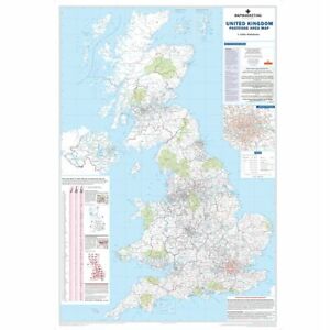
£11.49Free postage296 soldPostcode Map of The UK - Paper, Laminated And Framed Wall Map 120cm X 83cm
£26.99 to £84.99Free postageOrdiance Survey Maps. Multi-Listing. 1:50000, 1:25000, One-Inch maps. Used.
£1.95 to £3.50£2.50 postageOrdnance Survey Wall Map Poster Of Jarrow, Hebburn And Boldon - 1967 - 24" x 20"
£4.990 bids£4.99 postageEnding Sunday at 2:44PM BST5d 19hHadrian Wall.Ordnance Survey Explorer OL43. Haltwhistle & Hexham
£8.00£2.70 postagePoster Map Of Ipswich Town Centre – Excellent Condition Admap
£4.000 bidsEnding Sunday at 4:32PM BST5d 21h£4.99 postageOrdnance Survey One- Inch Map Of England Vintage Huge Job Lot X80
£79.99Free postageFINMERE - ORDNANCE SURVEY , 1:10,000 SCALE MAP , SHEET - SP 63 SW , 1982
£9.500 bids£5.99 postageEnding 7 May at 1:22PM BST7d 18hVintage RAC Tin Backed, Plastic Coated Map Of The UK
£10.000 bids£6.50 postageEnding Tuesday at 2:17PM BST19h 19mHistoric New Forest - map/poster
£9.00Free postageSTOWE PARK / SCHOOL - O/S , 1:10,000 SCALE MAP , SHEET - SP 63 NE , 1983
£9.500 bids£5.99 postageEnding 7 May at 1:22PM BST7d 18hUK A B Roads Motorway London Ireland Wall Map Laminated Large Wall Map 120X83cm
£24.99Free postage46 soldSweden Political Map For Business
£28.99£5.95 postageVintage Bartholomew’s Half-Inch Contoured Map- South Wales
£4.50£2.40 postage1980 Map of Guernsey - Issued by Guernsey Hotels Assoc. **VGC**
£2.95Free postageSLOUGH - ORDNANCE SURVEY , 1:10,000 SCALE MAP , SHEET = TQ 07 NW , 1989
£9.500 bids£5.99 postageEnding 7 May at 1:22PM BST7d 18hORDNANCE SURVEY MAP OF HADRIAN'S WALL 1975
£7.95Free postageVintage UK Wall Roller Map Circa 1952
£25.000 bidsEnding Friday at 10:26AM BST3d 15h£15.00 postageSector Map 8 Postcode London & M25 Wall Map With Motorway A & B Roads Paper Form
£28.94Free postage4 watchingOrdnance Survey Poster Maps X 16 22”x19” Each Warwickshire.
£40.000 bidsEnding Sunday at 3:08PM BST5d 20h£3.71 postageOS Ordnance Survey Geological Survey Map Sheet 265 BATH 1965 based on 1946 Rare
£15.000 bids£3.69 postageEnding Saturday at 11:36AM BST4d 16hSTRETTON ON DUNSMORE - O/S , 1:10,000 SCALE MAP , SHEET = SP 47 SW , 1966
£9.500 bids£5.99 postageEnding 7 May at 1:22PM BST7d 18hBRITISH GEOLOGICAL SURVEY MAP SHEET 326 and 340 SIDMOUTH 1964
£8.990 bidsEnding Thursday at 11:40PM BST3d 4h£2.88 postageGeddes & Grosset British Isles United Kingdom UK Britain Wall Map
£12.99Free postageScotland Road Wall Map Laminated Postcode Ferry Routes Motorways Size 91 x 114cm
£32.39Free postage18 watchingOXFORD - ORDNANCE SURVEY , 1:10,000 SCALE MAP , SHEET = SP 50 NW , 1977
£9.500 bids£5.99 postageEnding 7 May at 1:22PM BST7d 18hBRITISH GEOLOGICAL SURVEY MAP SHEET 112 CHESTERFIELD 1966
£8.990 bidsEnding Thursday at 11:41PM BST3d 4h£2.88 postageCARTERTON - ORDNANCE SURVEY , 1:10,000 SCALE MAP , SP 20 NE , 1982
£9.500 bids£5.99 postageEnding 7 May at 1:22PM BST7d 18hREADING - ORDNANCE SURVEY , 1:10,000 SCALE MAP , SHEET = SU 77 NW , 1973
£9.500 bids£5.99 postageEnding 7 May at 1:22PM BST7d 18hHadrian's Wall Country Map & Guide 2008 Folding Paper Sheet
£4.50Free postagePOOLE & AREA , ORDNANCE SURVEY LARGE SCALE MAPS & PLAN X 4
£20.000 bids£5.99 postageEnding 7 May at 1:26PM BST7d 18hWIMBORNE MINSTER / LEIGH , ORDNANCE SURVEY LARGE SCALE PLANS / MAPS X 2
£12.000 bids£5.99 postageEnding 7 May at 1:22PM BST7d 18h