
Cambridgeshire County Map Antique Europe Atlas Maps
35 results
1895 Cambridgeshire Original Antique County Map by G.W. Bacon
£19.99£4.50 postage1883 Cambridgeshire Original Antique Hand Coloured County Map by G.W. Bacon
£19.99£4.50 postage1808 Cambridgeshire Original Antique Hand Coloured County Map 212 Years Old
£19.99£2.00 postageCAMBRIDGESHIRE Original antique map, by Robert Morden c1722
£60.00£4.50 postageCAMBRIDGESHIRE Isle Of ELY, HUNTINGDON, Antique County Map c1886 Philips England
£7.990 bidsEnding Sunday at 8:28PM BST3d£1.00 postageCounty map of Cambridgeshire England hand coloured c1860
£9.00£2.50 postageBERKSHIRE. COUNTY MAP 1824 PUB G &WB WHITTAKER
£12.500 bids£2.00 postageEnding Sunday at 10:53PM BST3d 2horiginal 1875 colour map of cambridgeshire . engraved by sidney hall
£24.99Free postageCAMBRIDGESHIRE. COUNTY MAP 1824 PUB G &WB WHITTAKER
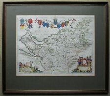
£12.500 bids£2.00 postageEnding Sunday at 10:53PM BST3d 2hCambridgeshire County Map by Pieter Van Den Keere, Circa 1632, Charles I, period
£145.000 bidsEnding 23 May at 7:45PM BST6d 23h£5.29 postage1695 COUNTY of CAMBRIDGESHIRE Original English Antique Map Robert Morden RARE
£65.00£4.00 postageBEDFORDSHIRE COUNTY MAP 1824 PUB G &WB WHITTAKER
£12.500 bids£2.00 postageEnding Sunday at 10:53PM BST3d 2hDugdale Archer Cambridgeshire 1c843 Curiosities E & W
£10.00£1.00 postageoriginal 1868 colour map of cambridgeshire
£24.99Free postageCAMBRIDGESHIRE, Robert Morden, original antique hand coloured map 1722
£115.00Free postage1830 Archibald Fullarton Antique Map of The English County of Cambridgeshire
£19.34£9.48 postage1831 Lewis Map Carnarvonshire Caernarfonshire Carnarvon Bangor Pwllheli Wales UK
£18.97Was: £23.71£15.80 postage1814 John Cary Road Map Cambridgeshire Cambridge Linton Ely Caxton England UK
£22.13Was: £27.66£15.80 postagePigot & Co County Colour Map Cambridgeshire 1840 Reproduction
£14.99£3.91 postage1845 Antique map - Cambridgeshire - from Reuben Ramble's. Scarce
£69.99£1.95 postage1831 Lewis Map Cambridgeshire Cambridge Linton Ely Caxton Wisebeah England UK
£18.97Was: £23.71£15.80 postage


![Ninja Foodi FlexDrawer Air Fryer - Certified Refurbished [AF500UK] 10.4L](https://i.ebayimg.com/thumbs/images/g/j3EAAOSwtGpmPiFA/s-l225.jpg)


