
Antique Reproduction Antique Maps, Atlases & Globes
Shop by Date Range
1,867 results
Beautiful Antique Framed Map by Willem Janszoon Blaeu, c. 1635
£9.990 bidsEnding 21 May at 9:32AM BST4d 15h£3.71 postageAntique Style Framed Map Of Lancashire
£22.99£4.45 postageWINCHESTER 1895 - Old Ordnance Survey Maps Godfrey Edition
£4.50£1.95 postageOld map of Glasgow, Scotland by Tallis in 1851
£20.99£4.00 postageFramed A4 Map of Pembrokeshire c.1660
£15.00£3.29 postage17th Century Surrey Described and Divided into Hundreds, Coloured John Speed Map
£120.000 bidsEnding Saturday at 6:58PM BST2d 1h£5.90 postageTaylor and Skinner Survey and Maps of Scotland 1776
£265.00£6.29 postageAntique Framed Map of Essex By John Norden 1594 Essex Record Office
£30.00£3.45 postageAntique Globe Swivel & Tilt By Insight Guides, New In Box
£15.00£2.94 postageSantons Map Of Herefordshire England 1577 Printed By Taylowe Ltd 1964 Framed
£8.000 bidsEnding Friday at 2:30PM BST20h 40m£9.00 postageCary’s Survey of the High Roads from London, 1790 north Set Facsimile reissue
£9.991 bid£3.25 postageEnding Today at 7:22PM BST1h 33mCary’s Survey of the High Roads from London, 1790 South Set Facsimile reissue
£9.991 bid£3.25 postageEnding Today at 7:22PM BST1h 33mNOTTINGHAM & DISTRICT 1906 - Old Ordnance Survey Maps Godfrey Edition
£4.50£1.95 postageReproduction - Map of Historic York - 18” x 15”
£5.00£1.55 postageOld Antique colour map views vignettes York, England 1800's 1851 Tallis Reprint
£5.99£2.50 postage6 watchingOld map of Bath by Tallis in 1851
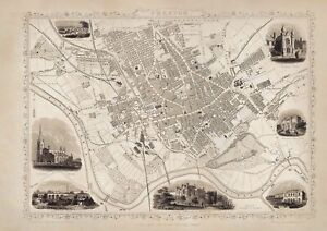
£20.99£4.00 postageOld Railways map of Great Britain by Tallis in 1851
£20.99£4.00 postageRare Vintage Map of the World By Johannes B Vrient Antwerp 1596 Reproduction
£85.00£9.00 postageBrass 18" Armillary Globe Sphere Engraved with Compass on Wooden Base~Home
£143.36Free postageFloor World Globe With Wooden Tripod Stand 18" Big Modern Map Atlas Globe Decor
£241.52Was: £274.46Free postageGLASGOW Large Maps, Plans And Narrative 1800 And Before
£12.00£5.00 postageLEICESTER (SW) 1902-1911 - Old Ordnance Survey Maps Godfrey Edition
£4.50£1.95 postageCHESTERFIELD 1914 - Old Ordnance Survey Maps Godfrey Edition
£4.50£1.95 postageOld map of Preston, Lancashire by Tallis in 1851
£20.99£4.00 postageFloor Globe With Wooden Tripod Stand 18" Big Modern Map Atlas Globe Decor
£279.00Free postage12" Brass Armillary Sphere with Arrow Nautical Maritime Astrolabe Globe/Home & O
£90.13£27.66 postageSUNDERLAND (East) 1895 - Old Ordnance Survey Maps Godfrey Edition
£4.50£1.95 postageVintage map of Cornwall, by Christopher sexton, dated 1575.
£30.00£8.00 postage10 watchingOld Antique Tudor map of Flintshire, Wales: John Speed 1600's 15" x 11 Reprint
£4.99£2.50 postage2 watchingOld map of Edinburgh, Scotland 1851 by Tallis in 1851
£20.99£4.00 postageOld Antique map Cumberland Cumbria England c1830's Moule: Reprint Carlisle View
£5.99£2.50 postage11 watchingBRIDGWATER 1903 - Old Ordnance Survey Maps Godfrey Edition
£4.50£1.95 postageUsed Replogle 9 Inch Globe Classic Series
£30.00£5.09 postageOld Antique Victorian picture map Canterbury, England 1800's Reprint: Cole Roper
£5.99£2.50 postage6 watchingHEREFORD - Large Maps, Plans And Narrative 1800 And Before
£12.00£5.00 postageOLD MAP OF NORTHAMPTON - 1807 - 20"x16" PHOTOGRAPHIC PRINT
£22.00£4.20 postageOld Antique Victorian map Gloucester, England: early 1800's 12 x 9" Cole & Roper
£5.99£2.50 postage4 watchingDEVONPORT (North) 1893 - Old Ordnance Survey Maps Godfrey Edition
£4.50£1.95 postageOld map of Southampton, Hampshire by Tallis in 1851
£20.99£4.00 postagePLYMOUTH (North) 1893 - Old Ordnance Survey Maps Godfrey Edition
£4.50£1.95 postage


![Ninja Foodi FlexDrawer Air Fryer - Certified Refurbished [AF500UK] 10.4L](https://i.ebayimg.com/thumbs/images/g/j3EAAOSwtGpmPiFA/s-l225.jpg)


