
1920-1929 Date Range Ordnance Survey Map Antique Folding Maps
134 results
Ordnance Survey one inch map of Manchester District. 1924.
£4.600 bids£2.30 postageEnding 15 May at 7:35PM BST3d 20hOrdnance Survey 1" Third Edition District Map of Dorking and Leith Hill District
£8.000 bidsEnding Sunday at 6:30PM BST19h 5m£1.55 postagec1920s Ordnance Survey 10 Mile Map of Great Britain - Sheets 1 2 & 3 Linen
£15.00£3.95 postageANTIQUE LEATHER CASED MAPS (40). 1923. PUBLISHED by MINISTRY OF TRANSPORT
£105.00£7.50 postageOrdnance Survey one inch District map of Southampton. 1928.
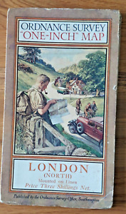
£5.082 bids£1.80 postageEnding 15 May at 7:33PM BST3d 20hOrdnance Survey one inch District map of London (North). 1925.
£4.601 bid£2.30 postageEnding 15 May at 7:37PM BST3d 20hOrdnance Survey one inch District map of Wye Valley. 1929.
£4.201 bid£1.80 postageEnding 15 May at 7:31PM BST3d 20hOrdnance Survey one inch Popular map of Sidmouth & Exmouth. 1927.
£3.400 bids£1.80 postageEnding 15 May at 7:38PM BST3d 20hOrdnance Survey Quarter Inch map England SE & London. Sheet 12A. 1929
£4.500 bids£2.30 postageEnding 15 May at 6:41PM BST3d 19hOrdnance Survey one inch Tourist map of Dorking & Leith Hill. 1929.
£4.501 bid£2.30 postageEnding 15 May at 7:29PM BST3d 20hVintage Cornwall Bartholomews Map 1920’s
£14.990 bids£4.00 postageEnding Sunday at 3:22PM BST15h 57mOrdnance Survey of Scotland 1 inch map of Sound of Sleat, Sheet 35, 1929
£3.450 bids£2.25 postageEnding 16 May at 5:41PM BST4d 18hOrdnance Survey one inch Tourist map of Brighton & South Downs. 1922/1938
£3.450 bids£2.25 postageEnding 16 May at 5:32PM BST4d 18h1920 Ordnance Survey Ipswich Vintage Map CLOTH PANELS
£12.99£2.70 postage1920 Ordnance Survey Road Map Of Rugby
£13.50£2.40 postageOrdnance Survey half inch layered map of Oxford & Swindon Sheet 28. 1927
£2.500 bids£1.90 postageEnding 15 May at 6:36PM BST3d 19hBartholomews Vintage Warwickshire Old Fold Out Cloth Map
£3.290 bidsEnding 17 May at 8:39PM BST5d 21h£2.85 postageVintage/antique Oxfordshire Bartholomews Map 1920’s
£0.990 bids£1.55 postageEnding 15 May at 10:53PM BST3d 23hOrdnance Survey half inch layered map SW Cornwall & Scilly Isles Sheet 35 1925
£2.800 bids£2.30 postageEnding 15 May at 6:35PM BST3d 19hc1920s BRISTOL DISTRICT Bacon's Cycling & Motoring ½" Cloth MAP With Index
£10.00£2.95 postageOrdnance Survey Quarter Inch map South Wales. Sheet 7A. 1929
£3.000 bids£2.30 postageEnding 15 May at 6:39PM BST3d 19hORDNANCE SURVEY CLOTH TOURIST MAP OF THE LAKE DISTRICT 1" TO 1 MILE 1920
£14.99£2.60 postageBartholomews Vintage Vale Of Severn Old Fold Out Cloth Map
£3.150 bidsEnding 17 May at 6:05PM BST5d 18h£2.85 postageOrdinance Survey Contoured Road Map of Birmingham no 72, c1930
£10.000 bidsEnding 14 May at 4:12PM BST2d 16h£2.00 postageORDNANCE SURVEY OF SCOTLAND POPULAR EDITION SHEET 77 ISLAND OF ARRAN
£10.00£2.50 postageVintage Ordnance Survey Map, Aldershot Command c1925 Military, 1" - 1 Mile
£19.99£2.99 postageVintage Lake District 3 x 2 maps Bartholomew & Ward locke & co Guide book
£20.00£3.00 postageOrdnance Survey Contoured Road Map of Barmouth and Aberystwyth (68)
£9.50Free postageBartholomews Vintage Maps x2 - Fold Out Paper Maps 1950s
£7.990 bidsEnding 16 May at 12:05PM BST4d 12h£1.35 postageVintage Ordnance Survey Map of Briton and Eastbourne 134 - 1920
£7.99£3.50 postageNER OS MAP NORTH SHIELDS PARCEL DELIVERIES 1920/1 EDITION ON LINEN
£25.00£4.00 postageORDNANCE SURVEY OF SCOTLAND POPULAR EDITION SHEET 73 FALKIRK AND MOTHERWELL
£10.00£2.50 postageNORTH BELFAST 1920 - Old Ordnance Survey Maps Godfrey Edition
£4.50£1.95 postageORDNANCE SURVEY OF SCOTLAND POPULAR EDITION SHEET 75 DUNBAR AND LAMMERMUIR
£10.00£2.50 postageORDNANCE SURVEY OF SCOTLAND POPULAR EDITION SHEET 53 SOUND OF MULL
£10.00£2.50 postageVintage Dorking & Leith Hill Ordnance Survey Fold Out Map, 1929
£9.99Free postage1921 Bartholomew's FORTH and TAY Cloth Map Sheet 5 - Scotland
£5.00£2.50 postageBartholomews Vintage Wye Valley Old Fold Out Cloth Map
£3.490 bidsEnding 17 May at 8:26PM BST5d 21h£2.85 postageORDNANCE SURVEY 1" TO 1 MILE POPULAR EDITION SHEET 30 BLACKBURN
£10.00£2.50 postageORDNANCE SURVEY 1" TO 1 MILE POPULAR EDITION SHEET 58 CROMER
£10.00£2.50 postageLEAMINGTON SPA 1923 - Old Ordnance Survey Maps Godfrey Edition
£4.50£1.95 postageBartholomews Vintage Exmoor Old Fold Out Cloth Map
£3.490 bidsEnding 17 May at 8:27PM BST5d 21h£2.85 postageEastern Counties (S) Vintage (1925) Ordnance Survey Map. 4 miles to 1".
£7.50£2.50 postageOrdnance Survey Map of GLASGOW, OBAN and the SOUTHERN ISLANDS, 1923-1933
£13.99£1.75 postageOrdnance Survey Map Sheet 8, Midlands c1926
£4.25Free postageOne-Inch Maps National Grid Ordnance Survey
£57.99£6.95 postage


You may also like
1910-1919 Date Range Ordnance Survey Map Antique Folding Maps
1930-1939 Date Range Ordnance Survey Map Antique Folding Maps
1900-1909 Date Range Ordnance Survey Map Antique Folding Maps
1940-1949 Date Range Ordnance Survey Map Antique Folding Maps
1920-1929 Date Range Ordnance Survey Map Antique Sheet Maps


Deals for you
Grab a further 10% with code BLUEBELL10Shop nowMin spend £9.99. Max discount £75.T&Cs apply.

![Ninja Foodi FlexDrawer Air Fryer - Certified Refurbished [AF500UK] 10.4L](https://i.ebayimg.com/thumbs/images/g/j3EAAOSwtGpmPiFA/s-l225.jpg)


