Northumberland 1700-1799 Date Range Antique Europe County Maps
SPONSOREDSPONSOREDSPONSOREDSPONSOREDSPONSORED
20 results
NORTHUMBERLAND, original antique county map, JOHN ROCQUE, 1769
£35.00Click & CollectNORTHUMBERLAND original antique county map, Thomas Kitchin, 1786
£28.00Click & CollectOriginal antique county map NORTHUMBERLAND, J.Ellis, c.1765
£50.00Click & Collector Best OfferOriginal antique copper-engraved map NORTHUMBERLAND, Badeslade & Toms, 1742
£25.00Click & CollectJ Cary County Map - Northumberland, Northamptonshire (1792) Hand Coloured
£9.990 bids£2.75 postageEnding Sunday at 7:28PM BST5d 2hClick & CollectNORTHUMBERLAND NEWCASTLE BY JOHN ROCQUE c1769 GENUINE ANTIQUE ENGRAVED MAP
£39.99Click & CollectNORTHUMBERLAND NEWCASTLE BY EMANUEL BOWEN c1720 GENUINE ANTIQUE ENGRAVED MAP
£34.99Click & CollectNORTHUMBERLAND, original antique map from 'Britannia Depicta', E. Bowen, 1759
£30.00Click & Collect1701 ROBERT MORDEN MAP OF WESTMORLAND Penrith Kendal Lake District
£24.99Click & Collector Best Offer£6.00 postageAntique map of Northumberland by Kitchen & Bowen 1767
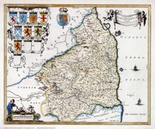
£65.00Click & Collector Best Offer£3.00 postageRADNORSHIRE RADNOR HOLY FARNE ISLAND c1769 BY JOHN ROCQUE GENUINE ANTIQUE MAP
£39.99Click & CollectAntique map of Northumberland by John Sellar, 1789 edition
£35.00Click & Collector Best Offer£4.00 postageISLANDS IN THE BRITISH OCEAN BY ROBERT MORDEN c1704 GENUINE ANTIQUE ENGRAVED MAP
£69.99Click & CollectOriginal antique map from 'Britannia Depicta' , NORTHUMBERLAND, Bowen, c.1724
£25.00Click & CollectRare antique road map COUNTY DURHAM, BERWICKSHIRE, BERWICK, Armstrong, 1776
£25.00Click & Collect1787 Antique Map; Northumberland after Francis Grose / John Seller
£12.99Click & Collect£1.95 postageAntique Map Of Durham By Thomas Kitchin c1786
£22.99Click & Collector Best Offer£4.20 postageNORTHUMBERLAND, Langley & Belch Original Antique County Map 1818
£65.00Click & CollectFree postage1795 Antique Map; Northumberland - John Lodge
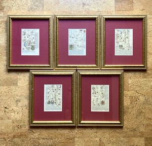
£29.99Click & Collect£3.90 postageSet 5 English Road Maps From Britannia Depicta, 1720s John Owen & Emanuel Bowen
£310.82£50.73 postage
You may also like
More to explore
- Bacon Map London in Antique Europe Maps & Atlases
- Bacon Map in Antique Europe Maps & Atlases
- Bromley Map in Antique Europe Maps & Atlases
- East Yorkshire Map
- Fox Hunting Maps
- Geographia Map in Antique Europe Maps & Atlases
- Great Yarmouth Map
- Hull Map in Antique Europe Maps & Atlases
- Jersey Map in Antique Europe Maps & Atlases
- Lambeth Map
- Linen Map in Antique Europe Maps & Atlases
- Map Cheltenham in Antique Europe Maps & Atlases
- Moule Maps
- Northern Ireland Map in Antique Europe Maps & Atlases
- Old Bristol Map
- Ordnance Survey Lake District in Antique Europe Maps & Atlases
- Philips Map in Antique Europe Maps & Atlases
- Plymouth Map in Antique Europe Maps & Atlases
- River Thames Map in Antique Europe Maps & Atlases
- Robert Morden Maps
- Saxon Map
- Saxton Map
- Scarborough Map in Antique Europe Maps & Atlases
- Vintage Michelin Maps in Antique Europe Maps & Atlases
- War Office Map in Antique Europe Maps & Atlases