
Antique European Maps & Atlases London Surrey
159 results
1902 Map of London and Vicinity antique vintage Britannica 10th
£10.00£2.40 postageantique Tombleson's map of river Thames with 9 inset views 1850 art print poster
£28.70£7.50 postage17 watchingantique Tombleson's Panoramic map of river Thames & Medway 1850 art print poster
£28.70£7.50 postage59 soldRiver Thames Old London Bridge Elizabethan view map Merian 1638 art poster print
£20.50£7.50 postage20 watchingChessington, Esher area - London map 100 years ago. Astonishing!
£25.00£4.50 postageHampton Court Park, London antique map 1920
£25.00£7.00 postageFramed Vodka map of the UK
£35.00Free postageVintage GEOGRAPHIA 50 Miles Around LONDON Paper Map - VG Cond
£5.00£2.50 postageAntique map of Cardiganshire, Published by James Wallis and C Hinton
£22.00£3.15 postage1792 Antique Map: That Part of Surrey which lies within 12 Miles of London
£29.99£1.95 postageOLD ORDNANCE SURVEY MAPS - BERMONDSEY & WAPPING 1872 - ALAN GODFREY MAPS
£2.99£1.70 postageRiver Thames antique Victorian excursions guide map Eton to Nore 1849 art poster
£18.90£7.50 postage9 watchingAntique Victorian Bennet's map river Thames Up down the River art print poster
£20.50£7.50 postage24 watchingOLD ORDNANCE SURVEY MAPS - PECKHAM 1914 - ALAN GODFREY MAPS
£2.99£1.70 postage100% ORIGINAL LONDON SURREY SUSSEX MAP BY M DRAYTON POLYOLBION C1612 SCARCE
£395.00£4.20 postageBartholomew 1:100,000 National Map Series 9: London & Surrey
£2.99£1.50 postage1821 The PARISH OF CHRIST CHURCH SURREY Scarce Hand Coloured London Plan
£75.00Free postage1792 Antique Map: That Part of Surrey which lies within 12 Miles of London
£29.99£1.95 postageSurrey Docks, Deptford old Map London 1888 #D26 Repro
£20.99£4.00 postageAntique map of Northamptonshire, Published by James Wallis and C Hinton
£22.00£3.15 postageAntique map of Derbyshire, Published by James Wallis and C Hinton
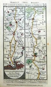
£22.00£3.15 postageantique road map of Tooting to Dorking published by J.Cary 1790
£30.000 bidsEnding 6 May at 6:34PM BST4d 8h£4.50 postageENGLAND EAST. Norfolk Suffolk Essex Kent Surrey Cambs; Inset London 1920 map
£10.00£5.00 postagec1920s Bartholomew's SURREY - NORTH LONDON Dissected Cloth Map
£10.00£2.95 postage1899 London ENGLAND Map ORIGINAL River Thames Ipswich RAILROADS Battlefields
£16.81£13.54 postage


You may also like


Deals for you
Grab a further 30% with code DYSONFLASH30.Shop nowPromotion organised by seller. T&Cs apply.


