
Wisconsin Antique North America Wall Maps
10 results
Jackson County Wisconsin Rockford/Marathon Wall Map 1946
£15.69£14.31 postageA4 Reprint of America Cities Towns States Map Superior Douglas Wisconsin
£5.95£2.25 postage1924 Raised 3D Topographic Map Wisconsin Whitewater La Grange Sheet US Geologic
£51.10£41.32 postagec1900 RACINE WISCONSIN AGRICULTURIST PAPER MAP ILLINOIS ON BACK GEO CRAM 29X 20"
£39.32£24.09 postageWisconsin Walworth County Highway Dept. Map May 1949, Revised 1977~16" × 18 3/4"
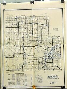
£10.06Was: £12.58£15.31 postageWood County, Wisconsin - 1951 State Highway Commission 28ʺ x 20" Map.
£5.940 bidsEnding 6 Jun at 1:52AM BST6d 14h£8.56 postageCanvas Reproduction, Vintage Pictorial Map of Wisconsin Ruth Taylor 1935
£15.72£17.99 postage21 watchingVintage Historical Landmarks of MONROE WISCONSIN Map Wall Art
£15.72£26.14 postageANTIQUE PLAT MAP TAYLOR COUNTY WISCONSIN 32" X 32" 1916 ORIGINAL OLD ADS MEDFORD
£78.64£25.41 postage4 watching


Deals for you
Grab a further 15% off with code MAYPAY15.Shop nowMin spend £9.99. Max discount £75.T&Cs apply.

![Ninja Foodi Dual Zone Air Fryer - Certified Refurbished [AF300UK] 6 Functions](https://i.ebayimg.com/thumbs/images/g/X6gAAOSwg7RmPiG0/s-l225.jpg)

![Shark FlexBreeze Portable Fan [FA220UK] Cordless](https://i.ebayimg.com/thumbs/images/g/MaQAAOSwlBxl1GfV/s-l225.jpg)


