Antique European Maps & Atlases Rutland 1800-1899 Date Range
SPONSOREDSPONSOREDSPONSOREDSPONSORED
59 results
1830 Rutland by Hoare & Reeves Large Antique Hand Coloured Map
£34.99Click & Collector Best Offer£4.50 postage1895 Leicestershire & Rutland Original Antique County Map by G.W. Bacon
£19.99Click & Collector Best Offer£4.50 postage1885 Leicestershire & Rutland Original Hand Coloured Antique Map by G.W. Bacon
£19.99Click & Collector Best Offer£4.50 postageoriginal 1868 colour map of the county of rutland
£28.00or Best OfferFree postagec1895 county Map of Leicester & Rutland England antique vintage Britannica 9th
£5.00Click & Collect£2.50 postageNew listing1888 MAP OF COLD OVERTON Leicestershire Sheet 27 SE, Rutland Sheet 4SE
£12.990 bidsor Best OfferEnding 24 May at 12:25PM BST6d 9h£5.49 postageClick & CollectAntique Original United Kingdom Map THOMAS MOULE C. 1837 RUTLAND RUTLANDSHIRE
£24.95Click & CollectCounty map of Rutlandshire England hand coloured c1860
£9.00Click & Collect£2.50 postage1850 Genuine Antique Map; Rutlandshire by Joshua Archer
£7.99Click & Collect£1.95 postageOld Victorian Colour Map Rutland, UK: 1840 Pigot Historical, Antique: Reprint
£5.99Click & Collector Best Offer£2.50 postageANTIQUE 18TH CENTURY COUNTY MAP THOMAS OSBORNE 1748 RUTLANDSHIRE RUTLAND
£18.95Click & CollectRUTLANDSHIRE RUTLAND BY THOMAS MOULE c1836 GENUINE ANTIQUE ENGRAVED MAP
£49.99Click & CollectAntique map of Rutland by Thomas Moules 1842
£15.00Click & CollectFree postage1808 Rutland Original Antique Hand Coloured County Map 212 Years Old
£19.99Click & Collector Best Offer£2.00 postage1863 Leicestershire & Rutland Original Antique Hand Coloured Weekly Dispatch Map
£19.99Click & Collector Best Offer£4.50 postage1886 Leicestershire & Rutland Antique Hand Coloured County Map by G.W. Bacon
£19.99Click & Collector Best Offer£4.50 postageRutlandshire Antique Colour Map by Thomas Moule County Maps of Old England 14”
£14.99Click & CollectFree postageAntique County Map of LEICESTER AND RUTLAND - Phillips Handy Atlas , 1887
£9.00Click & Collector Best Offer£0.85 postageRUTLAND COUNTY MAP 1824 PUB G &WB WHITTAKER
£12.500 bids£2.00 postageEnding Sunday at 10:52PM BST1d 19hClick & CollectUppingham S, Liddington, Stoke Dry, old map Rutland 1885: 13SW repro
£18.99Click & Collect£4.00 postageBelton, old map Rutland 1885: 12NE repro
£18.99Click & Collect£4.00 postageRUTLAND Antique Map c1845 by Archer for Dugdales
£7.99Click & Collect£0.99 postageWhissendine, old map Rutland 1884: 4NE repro
£18.99Click & Collect£4.00 postageOriginal antique GEOLOGICAL MAP, LEICESTERSHIRE, RUTLANDSHIRE, Reynolds, 1864-89
£26.00Click & CollectFree postageOld Map Reprint Sheet 44 Oakham England, Folded one inch to mile scale
£4.99£2.70 postage1 Inch Ordnance Maps Derbyshire, Nottinghamshi, Leicester , Rutland 1836 -4 Maps
£55.00Click & Collector Best Offer£3.20 postageGreat Casterton, Tickencote south, old map Rutland 1886: 10NE repro
£18.99Click & Collect£4.00 postage1840 County Map of RUTLAND For Lewis Topographical Dictionary 11" x 9"
£9.99Click & CollectFree postage1831 J & C Walker, Lewis Antique Map of The English County of Rutland
£28.96£9.46 postagec1840s Rutlandshire County Map Lewis Topographical Dictionary Plate Retford
£49.95Click & Collector Best OfferFree postagec1840s Rutlandshire County Map Lewis Topographical Dictionary Plate Retford Fair
£29.95Click & Collector Best OfferFree postagec1840s Rare Antique Original Rutlandshire County Map Archer Dugdales Print
£19.95Click & Collector Best OfferFree postageClipsham, old map Rutland 1884: 3SW repro
£18.99Click & Collect£4.00 postageCaldecott, old map Rutland 1885: 15NW repro
£18.99Click & Collect£4.00 postageRyhall, Belmesthorpe, old map Rutland 1885: 7SW repro
£18.99Click & Collect£4.00 postage1840'S 9X LOT ANTIQUE MAPS ARCHER / DUGDALES SOMERSET SUFFOLK SURREY SUSSEX ETC
£29.95Click & Collect£2.52 postageRUTLAND, Langley & Belch Original Antique County Map 1818
£35.00Click & CollectFree postageRUTLAND, Capper Original Hand Coloured Antique County Map 1808
£18.00Click & CollectFree postageRUTLANDSHIRE original antique english county map, Joshua Archer, 1847
£20.00Click & CollectFree postageMarket Overton, Thistleton, old map Rutland 1884: 2SW repro
£18.99Click & Collect£4.00 postage1804 (1858) Antique Map: Rutlandshire by Cole from Railway & Pedestrian Atlas
£14.99Click & Collect£1.95 postage1894 Vintage antique County Map of Leicester & Rutland by FS Weller in colour
£8.49Click & Collector Best Offer£1.99 postageLEICESTERSHIRE LEICESTER BY THOMAS MOULE c1840 GENUINE ANTIQUE ENGRAVED MAP
£39.99Click & Collectantiquarian Map Rutland Shire - 1845
£10.990 bidsor Best OfferEnding Sunday at 4:15PM BST1d 13h£3.99 postageClick & Collect1804 (1821) Antique Folding Map; Rutland. Charles Smith. Excellent Example
£59.99Click & Collect£3.90 postageOLD ANTIQUE MAP RUTLAND by J ARCHER c1840 19th CENTURY ENGRAVING
£15.99Click & Collect£2.20 postageOLD ANTIQUE MAP LEICESTERSHIRE RUTLAND by W & A K JOHNSTON PRINTED COLOUR 1880's
£16.99Click & Collect£2.20 postageOLD ANTIQUE MAP RUTLAND for LEWIS c1830s by CREIGHTON / WALKER 19th C ENGRAVING
£16.99Click & Collect£2.20 postage1840 ORIGINAL MAP GREAT BRITAIN IRELAND ENGLAND SCOTLAND WALES Dublin London
£43.41or Best Offer£12.63 postage1884 COUNTY MAP RUTLAND RAILWAYS ROADS STAMFORD OAKHAM UPPINGHAM
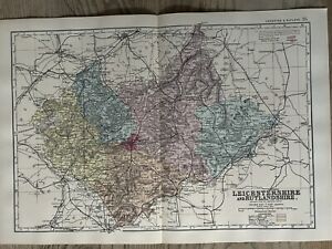
£44.00Click & CollectWas: £88.00or Best Offer£3.70 postage1892 VICTORIAN COUNTY MAP ~ LEICESTER & RUTLAND PARLIAMENTARY DIVISIONS BOROUGHS
£19.00Click & CollectWas: £38.00or Best Offer£3.50 postageWILLIAM HUGHES c1868 Map of Rutland County UK Coaching Routes
£15.79£7.10 postage1882 Antique COLOR Map / COUNTIES LEICESTER AND RUTLAND, ENGLAND
£15.78£11.80 postage1846 Antique Map of LEICESTERSHIRE & RUTLANDSHIRE by Slater published by Spigot
£23.68or Best Offer£36.74 postagec1845 Antique Map of RUTLANDSHIRE Rutland by J Archer (LSM34)
£14.00Click & CollectFree postagec1883 COUNTIES OF LEICESTERSHIRE & RUTLAND MAP Leicestershire (PC18)
£11.00Click & CollectFree postage1836 - Original Antique Map of RUTLANDSHIRE RUTLAND by Fullerton (FCM1)
£27.50Click & CollectFree postage1840 - Original Antique Map of "RUTLAND" by Thomas Moule Coloured (bm26)
£35.00Click & CollectFree postage1884 Antique Colour Map of the County of RUTLAND Rutlandshire by Letts (LCA27)
£16.50Click & Collect£4.00 postagec1840 Original Antique Map of RUTLAND by Thomas Moule (LSM16)
£35.00Click & CollectFree postage
You may also like
More to explore
- Bacon Map London in Antique Europe Maps & Atlases
- Bacon Map in Antique Europe Maps & Atlases
- Bromley Map in Antique Europe Maps & Atlases
- East Yorkshire Map
- Fox Hunting Maps
- Geographia Map in Antique Europe Maps & Atlases
- Great Yarmouth Map
- Hull Map in Antique Europe Maps & Atlases
- Jersey Map in Antique Europe Maps & Atlases
- Lambeth Map
- Linen Map in Antique Europe Maps & Atlases
- Map Cheltenham in Antique Europe Maps & Atlases
- Moule Maps
- Northern Ireland Map in Antique Europe Maps & Atlases
- Old Bristol Map
- Ordnance Survey Lake District in Antique Europe Maps & Atlases
- Philips Map in Antique Europe Maps & Atlases
- Plymouth Map in Antique Europe Maps & Atlases
- River Thames Map in Antique Europe Maps & Atlases
- Robert Morden Maps
- Saxon Map
- Saxton Map
- Scarborough Map in Antique Europe Maps & Atlases
- Vintage Michelin Maps in Antique Europe Maps & Atlases
- War Office Map in Antique Europe Maps & Atlases