Picture 1 of 1
Gallery
Picture 1 of 1

Have one to sell?
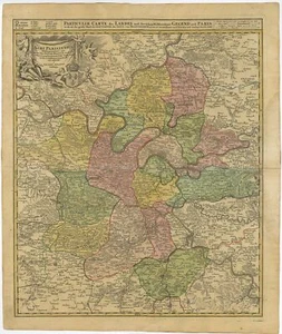
Antique Map of the Region of Paris by Homann Heirs (c.1720)

US $234.79
Approximately£176.55
or Best Offer
Condition:
- Buy it nowAntique Map of the Region of Paris by Homann Heirs (c.1720)
Oops! Looks like we're having trouble connecting to our server.
Refresh your browser window to try again.
Postage:
Free Standard Shipping.
Located in: Langweer, Netherlands
Delivery:
Estimated between Wed, 13 Aug and Tue, 19 Aug to 94104
Returns:
No returns accepted.
Payments:
Shop with confidence
Seller assumes all responsibility for this listing.
eBay item number:115063568012
Item description from the seller
Seller business information
About this seller

Bartele Gallery
100% positive Feedback•906 items sold
Registered as a business seller
Popular categories from this shop
Seller Feedback (316)
- 4***e (1)- Feedback left by buyer.Past 6 monthsVerified purchaseItem arrived quickly and was exactly as described. Packaging was secure and protected the item well. Great value for the price. Very happy with the purchase and would buy again from this seller.Antique Print of the Hongi or Coracora Fleet by Valentijn (1726) (#114391617829)
- c***i (331)- Feedback left by buyer.Past 6 monthsVerified purchaseI love my etching. It appears to be of the inn my husband and I stayed in while in Brugge. The seller is excellent. Quick communication, fair pricing and the BEST packaging. Thanks I will treasure this.
- n***s (147)- Feedback left by buyer.Past 6 monthsVerified purchaseI have bought from this seller multiple times before, and I'm always extremely happy with them! They package your stuff really well, and what I order is always in perfect condition when I open it. I cannot recommend them enough.
More to explore:
- Homann Heirs Antique Maps, Atlases & Globes,
- Antique European Maps & Atlases Homann Heirs,
- Antique European Maps Homann Heirs 1700-1799 Date Range Atlases,
- Paris Antique Europe Atlas Maps,
- Paris Antique Europe Sheet Maps,
- Antique European Maps & Atlases Paris,
- Paris 1910-1919 Date Range Antique Europe City Maps,
- Antique European Maps & Atlases Paris 1920-1929 Date Range,
- Antique European Maps & Atlases Paris 1700-1799 Date Range,
- Paris 1800-1899 Date Range Antique Europe City Maps
Popular categories from this shop
Seller Feedback (316)
- 4***e (1)- Feedback left by buyer.Past 6 monthsVerified purchaseItem arrived quickly and was exactly as described. Packaging was secure and protected the item well. Great value for the price. Very happy with the purchase and would buy again from this seller.Antique Print of the Hongi or Coracora Fleet by Valentijn (1726) (#114391617829)
- c***i (331)- Feedback left by buyer.Past 6 monthsVerified purchaseI love my etching. It appears to be of the inn my husband and I stayed in while in Brugge. The seller is excellent. Quick communication, fair pricing and the BEST packaging. Thanks I will treasure this.
- n***s (147)- Feedback left by buyer.Past 6 monthsVerified purchaseI have bought from this seller multiple times before, and I'm always extremely happy with them! They package your stuff really well, and what I order is always in perfect condition when I open it. I cannot recommend them enough.