
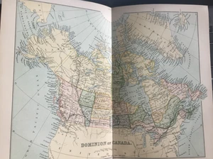
Antique 1870s Map – Dominion of Canada – Fold-Out Colour Print – Original
£13.99£13.99
Thu, 07 Aug, 08:10Thu, 07 Aug, 08:10
Picture 1 of 7


Gallery
Picture 1 of 7


Have one to sell?
Antique 1870s Map – Dominion of Canada – Fold-Out Colour Print – Original
£13.99
Condition:
Oops! Looks like we're having trouble connecting to our server.
Refresh your browser window to try again.
Postage:
£4.95 Standard Int'l Postage.
Located in: Great Torrington, Devon, United Kingdom
Delivery:
Estimated between Wed, 13 Aug and Fri, 22 Aug
Returns:
No returns accepted.
Payments:
Get more time to pay. See payment informationfor PayPal Credit - opens in a new window or tab
Shop with confidence
Seller assumes all responsibility for this listing.
eBay item number:136119708711
Item specifics
- Antique
- Yes
- Printing Technique
- Lithography
- US State
- Alaska
- Cartographer/Publisher
- William McKenzie
- City
- Vancouver
- Date Range
- 1800-1899
- Type
- World Atlas
- Format
- Atlas
- Mexican State
- various
- Year
- 1870
- Canadian Province
- Ontario
- Era
- 1800s
- Original/Reproduction
- Antique Original
- Country/Region
- Canada
Item description from the seller
Seller business information
Seller Feedback
No Feedback yet
More to explore:
- Antique Original Antique Folding Maps,
- Antique Original City Map Antique Folding Maps,
- Antique Original County Map Antique Folding Maps,
- Lithography Antique Original Antique Folding Maps,
- Antique Original Antique World Folding Maps,
- Antique Original County Map Antique Europe Folding Maps,
- Vintage Original Topographical Map Antique Folding Maps,
- Lithography Antique Original Antique World Folding Maps,
- Cornwall Antique Original Antique Europe Folding Maps,
- Vintage Original Antique World Folding Maps