Picture 1 of 4


Gallery
Picture 1 of 4


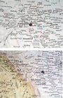
1951 ORIGINAL VINTAGE MAP OF ALBERTA EDMONTON CALGARY / SASKATCHEWAN / CANADA
US $26.78
Approximately£20.18
or Best Offer
Condition:
“PLEASE CLICK ON *SEE DESCRIPTION* OR SCROLL DOWN TO SEE MORE DETAILS AND PHOTOS.”
Oops! Looks like we're having trouble connecting to our server.
Refresh your browser window to try again.
Postage:
Free Standard Shipping from Canada.
Located in: Montreal, Quebec, Canada
Delivery:
Estimated between Mon, 12 May and Fri, 16 May to 43230
Returns:
60 days return. Seller pays for return postage.
Payments:
Shop with confidence
Seller assumes all responsibility for this listing.
eBay item number:156793137951
Item specifics
- Seller notes
- “PLEASE CLICK ON *SEE DESCRIPTION* OR SCROLL DOWN TO SEE MORE DETAILS AND PHOTOS.”
- SHEET SIZE
- 13 3/4" x 10 3/4" (35 x 27 cm)
- Canadian Province
- Alberta, Saskatchewan
- Format
- Atlas Map
- Type
- Map
- Year
- 1951
- Country/Region
- Canada
- Topic
- Maps
- Publication Year
- 1951
- Maker
- Rand McNally
- Date Range
- 1950-1959
Item description from the seller
Seller business information
Seller Feedback
No Feedback yet
More to explore:
- Antique North American Maps & Atlases Saskatchewan,
- Antique North American Maps & Atlases Alberta,
- Vintage Original County Map Antique Folding Maps,
- Vintage Original County Map Antique Sheet Maps,
- Vintage Original Nautical Map Antique Sheet Maps,
- Vintage Original City Map Antique Sheet Maps,
- Vintage Original Antique Folding Maps,
- Vintage Original Antique School Maps,
- Vintage Original Antique Sheet Maps,
- Vintage Original Antique Atlas Maps