Picture 1 of 2

Gallery
Picture 1 of 2


Have one to sell?
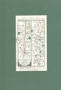
North Yorkshire - Northumberland
£21.23
Condition:
“Very good condition”
- Buy it nowNorth Yorkshire - Northumberland road map by Daniel Paterson c1785
Oops! Looks like we're having trouble connecting to our server.
Refresh your browser window to try again.
Postage:
Located in: Aylesbury, United Kingdom
Delivery:
Varies
Returns:
No returns accepted.
Payments:
Get more time to pay. See payment informationfor PayPal Credit - opens in a new window or tab
Shop with confidence
Seller assumes all responsibility for this listing.
eBay item number:167671692879
Item specifics
- Seller notes
- “Very good condition”
- Antique
- Yes
- Date Range
- 1700-1799
- Type
- Road strip map
- Format
- Strip map
- Printing Technique
- Copper Plate
- Year
- 1785
- Era
- 1700s
- Cartographer/Publisher
- Daniel Paterson
- Original/Reproduction
- Antique Original
- City
- Richmond
- Country/Region
- England
- County
- Northumberland, Yorkshire
Item description from the seller
About this seller
jonart8
100% positive Feedback•608 items sold
Registered as a private sellerThereby, consumer rights stemming from EU consumer protection law do not apply. eBay buyer protection still applies to most purchases.
Seller Feedback (241)
- m***a (404)- Feedback left by buyer.Past yearVerified purchaseExcellent seller great item as described, fast postage and well packaged great value and excellent communication thank youReply from: jonart8- Feedback replied to by seller jonart8.- Feedback replied to by seller jonart8.Thanks for you feedback I'm pleased you like itA fine framed antique lithograph advertising Louis Vuitton Luggage c1900 (#167163829596)
- w***r (168)- Feedback left by buyer.Past 6 monthsVerified purchaseItem as described and delivered promptly in good condition. Very good value.Reply from: jonart8- Feedback replied to by seller jonart8.- Feedback replied to by seller jonart8.Thank you
- w***w (52)- Feedback left by buyer.Past yearVerified purchaseFast Postage! Excellent packaging! Thank you!Framed lithograph of the planet Saturn by E E Barnard c1896 (#167264425165)
More to explore:
- Northumberland Antique County Maps,
- Northumberland County Map Antique Europe Sheet Maps,
- Northumberland Antique Europe Atlas Maps,
- Northumberland Antique Europe Sheet Maps,
- Northumberland Antique Europe Folding Maps,
- Northumberland Antique Europe Topographical Maps,
- Northumberland Antique Europe Ordnance Survey Maps,
- Yorkshire County Map Antique Europe Sheet Maps,
- Yorkshire Antique Europe County Maps,
- Yorkshire Antique Europe Topographical Maps