
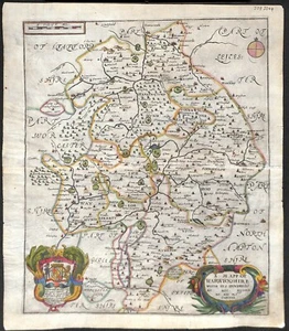
Antique map, Blome, Warwickshire, Description of the Kingdoms of England, 1673
£100.00£100.00
Sun, 15 Jun, 22:17Sun, 15 Jun, 22:17
Picture 1 of 2

Gallery
Picture 1 of 2


Antique map, Blome, Warwickshire, Description of the Kingdoms of England, 1673

£100.00
or Best Offer
From £8.90 per month for 12 months with *
Condition:
“Good condition”
Oops! Looks like we're having trouble connecting to our server.
Refresh your browser window to try again.
Postage:
£16.00 Royal Mail International Tracked.
Located in: Chichester, United Kingdom
Delivery:
Estimated between Tue, 8 Jul and Wed, 16 Jul to 94104
Returns:
30 days return. Buyer pays for return postage. If you use an eBay delivery label, it will be deducted from your refund amount.
Payments:
*From £8.90 per month for 12 months.
Shop with confidence
Seller assumes all responsibility for this listing.
eBay item number:175982819708
Item specifics
- Seller notes
- “Good condition”
- Date Range
- 1600-1699
- Type
- Topographical Map
- Printing Technique
- Copper Plate
- Format
- Atlas Map
- Year
- 1673
- Cartographer/Publisher
- Blome. richard
- Original/Reproduction
- Antique Original
- Country/Region
- England
- County
- Warwickshire
Item description from the seller
Seller business information

Seller Feedback (700)
- a***e (227)- Feedback left by buyer.Past 6 monthsVerified purchaseThis is my second contact with this seller. My opinion after the fiirst one was very positive. The item was delivered to Poland in relative short time and was in really good condition. This time I have ordered 3 items, combined delivery to UK. Delivery was immediate and the delivery cost was really low.
- b***c (54)- Feedback left by buyer.Past 6 monthsVerified purchaseSplendid map, carefully packaged and as described. Good value for money Thank you.
- e***m (179)- Feedback left by buyer.Past 6 monthsVerified purchaseExcellent transaction. Item as described and delivered quickly.Carto-bibliography, Ortelius Atlas Maps, Van den Broecke (#176860652811)
More to explore:
- Warwickshire Antique Europe Atlas Maps,
- Warwickshire Antique Europe Sheet Maps,
- Antique European Maps & Atlases Warwickshire,
- Warwickshire Antique Europe County Maps,
- Warwickshire Antique Europe Folding Maps,
- Warwickshire Antique Reproduction Antique Europe Sheet Maps,
- Warwickshire Antique Reproduction Antique European Maps & Atlases,
- Antique European Maps & Atlases Warwickshire 1700-1799 Date Range,
- Warwickshire 1800-1899 Date Range Antique Europe County Maps,
- Antique European Maps & Atlases Warwickshire 1600-1699 Date Range
Seller Feedback (700)
- a***e (227)- Feedback left by buyer.Past 6 monthsVerified purchaseThis is my second contact with this seller. My opinion after the fiirst one was very positive. The item was delivered to Poland in relative short time and was in really good condition. This time I have ordered 3 items, combined delivery to UK. Delivery was immediate and the delivery cost was really low.
- b***c (54)- Feedback left by buyer.Past 6 monthsVerified purchaseSplendid map, carefully packaged and as described. Good value for money Thank you.
- e***m (179)- Feedback left by buyer.Past 6 monthsVerified purchaseExcellent transaction. Item as described and delivered quickly.Carto-bibliography, Ortelius Atlas Maps, Van den Broecke (#176860652811)