Picture 1 of 8


Gallery
Picture 1 of 8


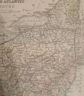
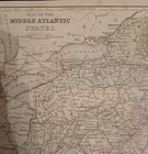
Antique 1887 Hand Colored Map Of The Middle Atlantic States Incl; NY,NJ,PA,WV,VA
US $21.99
Approximately£16.38
or Best Offer
Condition:
- Buy it nowAntique 1887 Hand Colored Map Of The Middle Atlantic States Incl; NY,NJ,PA,WV,VA
Oops! Looks like we're having trouble connecting to our server.
Refresh your browser window to try again.
Postage:
US $2.72 (approx £2.03) USPS First Class Large Envelope.
Located in: Columbia, Pennsylvania, United States
Delivery:
Estimated between Fri, 24 Oct and Thu, 30 Oct
Returns:
No returns accepted.
Payments:
Shop with confidence
Seller assumes all responsibility for this listing.
eBay item number:176573670095
Item specifics
- Date Range
- 1887
- Type
- Political Map
- US State
- NY, PA, NJ, WV, VA, MD
- Format
- Atlas Map
- Printing Technique
- Copper Plate
- Year
- 1887
- Original/Reproduction
- Antique Original
- Cartographer/Publisher
- Cowperthwaite and Co
- Country/Region
- United States of America
Item description from the seller
About this seller
The Wandering Jew Antiques
99.5% positive Feedback•573 items sold
Registered as a private sellerThereby, consumer rights stemming from EU consumer protection law do not apply. eBay buyer protection still applies to most purchases.
Seller Feedback (256)
- e***o (2095)- Feedback left by buyer.Past 6 monthsVerified purchaseSimply stunning, just as described. It's a treasure! The price plus the cost of shipping was reasonable, especially considering the extreme care taken to pack this item properly so it arrived undamaged. Thank you so much! Would definitely buy from seller again.
- e***l (434)- Feedback left by buyer.Past 6 monthsVerified purchaseI’m thrilled with my recent eBay purchase. The seller was prompt and professional. The shipment was timely and was well-packaged. It exceeded my expectations in quality and detail. I highly recommend this seller to collectors seeking authenticity and exceptional customer service.
- m***4 (2061)- Feedback left by buyer.Past 6 monthsVerified purchaseWell packed and arrived expeditiously. Seller accepted my offer which was greatly appreciated. Reasonable price and the inclusion of a postcard from the Library of Congress was a welcomed bonus.
More to explore:
- Manuscript/Hand drawn Antique Maps, Atlases & Globes,
- Antique Silver Stately,
- Antique Original County Map Antique Folding Maps,
- Antique Original Nautical Map Antique Sheet Maps,
- Antique Original Geological Map Antique Sheet Maps,
- Antique Original County Map Antique Atlas Maps,
- Antique Original City Map Antique Sheet Maps,
- Nautical Map Antique Folding Maps,
- City Map Antique Sheet Maps,
- Geological Map Antique Atlas Maps