Picture 1 of 15


Gallery
Picture 1 of 15


Have one to sell?
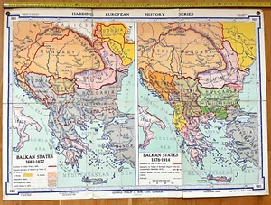
Harding ‘The Balkan States (1683–1919)’ Wall Map Number H21
£57.40
or Best Offer
Condition:
“This map is in fair to good condition for its age, showing signs of use typical of a classroom ”... Read moreAbout condition
- Buy it nowHarding ‘The Balkan States (1683–1919)’ Wall Map Number H21
Oops! Looks like we're having trouble connecting to our server.
Refresh your browser window to try again.
Postage:
Located in: Reading, United Kingdom
Delivery:
Varies
Returns:
No returns accepted.
Payments:
Get more time to pay. See payment informationfor PayPal Credit - opens in a new window or tab
Shop with confidence
Seller assumes all responsibility for this listing.
eBay item number:197047599288
Item specifics
- Seller notes
- Format
- Wall Map
- Cartographer/Publisher
- Denoyer-Geppert
- Original/Reproduction
- Vintage Original
Item description from the seller
About this seller
duobox
100% positive Feedback•234 items sold
Registered as a private sellerThereby, consumer rights stemming from EU consumer protection law do not apply. eBay buyer protection still applies to most purchases.
Seller Feedback (145)
- k***1 (7)- Feedback left by buyer.Past 6 monthsVerified purchaseItem was posted as promised. The packaging was protectively packaged. I believe the product is good value for my money . Postage was a bit on the high side
- d***d (19)- Feedback left by buyer.Past 6 monthsVerified purchaseArrived very quickly, it was well packaged and was exactly as described. Very good service.
- 2***_ (767)- Feedback left by buyer.Past 6 monthsVerified purchaseArrived safely, very well packed, thank you. Great seller and communication. All the best.LAND ROVER Series IIA 1961 Brochure - Publication 609/A plus Sept 61 Price List (#196560538155)
More to explore:
- Railroad Map Antique Wall Maps,
- County Map Antique Wall Maps,
- City Map Antique Wall Maps,
- Antique Wall Maps,
- City Map Antique Europe Wall Maps,
- Antique Curiosities Wall Maps,
- Antique World Wall Maps,
- Reproduction Antique Wall Maps,
- 1910-1919 Date Range Ordnance Survey Map Antique Folding Maps,
- 1910-1919 Date Range Ordnance Survey Map Antique Sheet Maps