Picture 1 of 2

Gallery
Picture 1 of 2


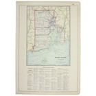
RHODE ISLAND State MAP 1928 21"x14" Jazz Age 1920s VINTAGE Large Full COLOR
US $52.50
Approximately£39.46
or Best Offer
Condition:
“Very Good Used condition, there are no tears to the printed area but there may be small tears to the ”... Read moreAbout condition
Oops! Looks like we're having trouble connecting to our server.
Refresh your browser window to try again.
Postage:
Located in: Tonawanda, New York, United States
Delivery:
Varies
Returns:
30 days return. Seller pays for return postage.
Payments:
Shop with confidence
Seller assumes all responsibility for this listing.
eBay item number:205436344047
Item specifics
- Seller notes
- US State
- Rhode Island
- City
- MULTIPLE
- Format
- Atlas Map
- Type
- County Map
- Date Range
- 1920-1929
- Original/Reproduction
- Vintage Original
- Country/Region
- United States of America
- Printing Technique
- Cerographic Engraving
- Cartographer/Publisher
- George F. Cram Company
- Year
- 1928
Item description from the seller
Seller business information
Seller Feedback
No Feedback yet
More to explore:
- Antique North American Maps & Atlases Rhode Island,
- Rhode Island Antique North America City Maps,
- Newport Rhode Island Antique North America Maps & Atlases,
- Rhode Island Antique Original Antique North American Maps & Atlases,
- Rhode Island Antique North American Maps & Atlases 1800-1899 Date Range,
- Vintage Original 1920-1929 Date Range Antique Ordnance Survey Maps,
- 1920-1929 Antique Ordnance Survey Maps,
- 1920-1929 Date Range Ordnance Survey Map Antique Sheet Maps,
- 1920-1929 Date Range Ordnance Survey Map Antique Folding Maps,
- 1920-1929 Date Range Antique Nautical Maps