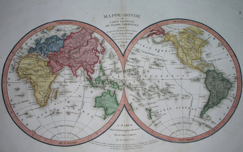
1834 ORIGINAL MAP UNITED STATES CANADA TEXAS FLORIDA NORTH AMERICA ASIA WORLD
US $74.99US $74.99
Sat, 03 May, 23:05Sat, 03 May, 23:05
Picture 1 of 10


Gallery
Picture 1 of 10


Have one to sell?
1834 ORIGINAL MAP UNITED STATES CANADA TEXAS FLORIDA NORTH AMERICA ASIA WORLD
Condition:
“SOME STAINS, SOME SCATTERED SPOTTING AND FOXING //// I INVITE YOU TO MY SHOP //////”
Ended: 03 May, 2025 23:05:55 BST
Oops! Looks like we're having trouble connecting to our server.
Refresh your browser window to try again.
Postage:
US $16.00 (approx £11.91) Economy Shipping from outside US.
Located in: Zary, Poland
Delivery:
Estimated between Mon, 4 Aug and Fri, 15 Aug to 94104
Returns:
60 days return. Buyer pays for return postage. If you use an eBay delivery label, it will be deducted from your refund amount.
Payments:
Shop with confidence
Seller assumes all responsibility for this listing.
eBay item number:205443318542
Item specifics
- Seller notes
- “SOME STAINS, SOME SCATTERED SPOTTING AND FOXING //// I INVITE YOU TO MY SHOP //////”
- Printing Technique
- Copper Plate
- US State
- AK, HI, AL, FL, GA, MS, NC, SC, Alabama, Alaska, AR, IA, KS, LA, MO, NE, Arizona, Arkansas, AZ, CA, CO, NM, NV, UT, California, Colorado, Connecticut, CT, MA, ME, NH, RI, VT, DC, DE, MD, NJ, NY, PA, Florida, Georgia, Idaho, Illinois, Indiana, Iowa, Louisiana, Mississippi, New Mexico, New York, Oklahoma, Oregon, Pennsylvania, Texas, Virginia, Washington, West Virginia
- Cartographer/Publisher
- Delamarche / Vaugondy
- City
- San Antonio Chicago New York Washington Trenton
- Date Range
- 1700-1799
- Continent
- North America
- Type
- Political Map
- Mexican State
- Aguascalientes, Baja California, Baja California Sur, Campeche, Chiapas, Chihuahua, Coahuila, Colima, Durango, Guanajuato, Guerrero, Hidalgo, Jalisco, Michoacán, Morelos, Nayarit, Nuevo León, Oaxaca, Puebla, Querétaro, Quintana Roo, San Luis Potosí, Sinaloa, Sonora, Tabasco, Tamaulipas, Tlaxcala, Veracruz, Yucatán, Zacatecas
- Format
- Atlas Map
- Canadian Province
- Alberta, British Columbia, Manitoba, New Brunswick, Newfoundland & Labrador, Northwest Territories, Nova Scotia, Nunavut, Ontario, Prince Edward Island, Quebec, Saskatchewan, Yukon
- Year
- 1834 - dated map
- Original/Reproduction
- Antique Original
- Topic
- Maps
- Country/Region
- United States
Item description from the seller
Seller business information
Seller Feedback
No Feedback yet
More to explore:
- Florida Antique Original Antique North America Maps & Atlases,
- Florida Antique North America Wall Maps,
- Florida Antique North America City Maps,
- Florida Antique North America Railroad Maps,
- Florida Antique North America Sheet Maps,
- Vintage Original Antique North America Topographical Maps,
- Antique Original Antique North America Political Maps,
- Antique Original Antique North America Maps & Atlases,
- Antique Original Antique North America Folding Maps,
- Vintage Original Antique North America Folding Maps