Picture 1 of 3


Gallery
Picture 1 of 3


Have one to sell?
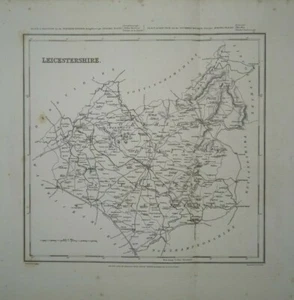
Antique map of Leicestershire by Samuel Lewis 1834

£18.00
Condition:
- Buy it nowAntique map of Leicestershire by Samuel Lewis 1834
Oops! Looks like we're having trouble connecting to our server.
Refresh your browser window to try again.
Postage:
£12.00 Royal Mail International Tracked.
Located in: Bath, United Kingdom
Delivery:
Estimated between Mon, 11 Aug and Mon, 18 Aug to 94104
Returns:
No returns accepted.
Payments:
Get more time to pay. See payment informationfor PayPal Credit - opens in a new window or tab
Shop with confidence
Seller assumes all responsibility for this listing.
eBay item number:254790220987
Item specifics
- County
- Leicestershire
- Cartographer/Publisher
- Samuel Lewis
- Printing Technique
- Lithography
- Original/Reproduction
- Antique Original
- Type
- Topographical Map
- Year
- 1834
- Date Range
- 1800-1899
- Country/Region
- England
- Era
- 1800s
Item description from the seller
Seller business information
About this seller

michaelmapman
100% positive Feedback•1.1K items sold
Registered as a business seller
Popular categories from this shop
Seller Feedback (486)
- s***b (102)- Feedback left by buyer.Past monthVerified purchaseThis fine example of Cary's ability as an engraver was delivered within three days of being ordered was exactly as described and arrived well-protected in a robust cardboard tube - not even a postage charge! Thankyou, Michael, for running your business at such a high standard of service.
- n***e (1751)- Feedback left by buyer.Past monthVerified purchaseTerrific seller! Lovely print, well packaged and quickly shipped. Thank you!!
- 0***1 (1587)- Feedback left by buyer.Past 6 monthsVerified purchaseReceived OK, great map, well packaged, easy transaction, A1.
This is a private listing and your identity will not be disclosed to anyone except the seller.
More to explore:
- Leicestershire Antique Europe Topographical Maps,
- Antique European Maps & Atlases Leicestershire,
- Leicestershire Antique Europe Atlas Maps,
- Leicestershire Antique Europe Sheet Maps,
- Leicestershire Antique Europe County Maps,
- Leicestershire Ordnance Survey Map Antique Europe Sheet Maps,
- John Speed Leicestershire Antique Europe Maps & Atlases,
- Leicestershire 1930-1939 Date Range Antique Europe Sheet Maps,
- Leicestershire Antique Reproduction Antique European Maps & Atlases 1900-1909 Date Range,
- Antique European Maps & Atlases Leicestershire 1900-1909 Date Range
Popular categories from this shop
Seller Feedback (486)
- s***b (102)- Feedback left by buyer.Past monthVerified purchaseThis fine example of Cary's ability as an engraver was delivered within three days of being ordered was exactly as described and arrived well-protected in a robust cardboard tube - not even a postage charge! Thankyou, Michael, for running your business at such a high standard of service.
- n***e (1751)- Feedback left by buyer.Past monthVerified purchaseTerrific seller! Lovely print, well packaged and quickly shipped. Thank you!!
- 0***1 (1587)- Feedback left by buyer.Past 6 monthsVerified purchaseReceived OK, great map, well packaged, easy transaction, A1.