Picture 1 of 4


Gallery
Picture 1 of 4


Have one to sell?
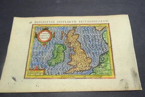
Antique Map of Great Britain and Ireland by Petrus Bertius 1618

£85.00
Condition:
- Buy it nowAntique Map of Great Britain and Ireland by Petrus Bertius 1618
Oops! Looks like we're having trouble connecting to our server.
Refresh your browser window to try again.
Postage:
£10.00 Royal Mail International Signed.
Located in: Bath, United Kingdom
Delivery:
Estimated between Tue, 23 Sep and Thu, 2 Oct to 94104
Returns:
No returns accepted.
Payments:
Get more time to pay. See payment informationfor PayPal Credit - opens in a new window or tab
Shop with confidence
Seller assumes all responsibility for this listing.
eBay item number:256487128415
Item specifics
- Date Range
- 1600-1699
- Type
- Topographical Map
- Printing Technique
- Copper Plate
- Year
- 1618
- Era
- 1600s
- Cartographer/Publisher
- Petrus Bertius
- Original/Reproduction
- Antique Original
- Country/Region
- England, Ireland, Scotland, Wales
- Country/Region of Manufacture
- United Kingdom
Item description from the seller
Seller business information
About this seller

michaelmapman
100% positive Feedback•1.1K items sold
Registered as a business seller
Popular categories from this shop
Seller Feedback (494)
- s***b (102)- Feedback left by buyer.Past 6 monthsVerified purchaseThis fine example of Cary's ability as an engraver was delivered within three days of being ordered was exactly as described and arrived well-protected in a robust cardboard tube - not even a postage charge! Thankyou, Michael, for running your business at such a high standard of service.
- n***e (1759)- Feedback left by buyer.Past monthVerified purchaseTerrific seller! Lovely print, well packaged and quickly shipped. Thank you!!
- 0***1 (1598)- Feedback left by buyer.Past 6 monthsVerified purchaseReceived OK, great map, well packaged, easy transaction, A1.Antique map of Lincolnshire by Alexander Hogg and Thomas Conder 1784 (#256278250290)
More to explore:
- Petrus Bertius Antique Maps, Atlases & Globes,
- Antique European Maps & Atlases Petrus Bertius,
- Petrus Bertius Antique Original Antique European Maps & Atlases,
- Petrus Bertius Copper Plate Antique European Maps & Atlases,
- Antique European Maps Petrus Bertius 1600-1699 Date Range Atlases,
- Ireland Marine & Maritime Antiques,
- Antique Original City Map Antique Sheet Maps,
- Nautical Map Antique Folding Maps,
- City Map Antique Folding Maps,
- Topographical Map Antique Sheet Maps
Popular categories from this shop
Seller Feedback (494)
- s***b (102)- Feedback left by buyer.Past 6 monthsVerified purchaseThis fine example of Cary's ability as an engraver was delivered within three days of being ordered was exactly as described and arrived well-protected in a robust cardboard tube - not even a postage charge! Thankyou, Michael, for running your business at such a high standard of service.
- n***e (1759)- Feedback left by buyer.Past monthVerified purchaseTerrific seller! Lovely print, well packaged and quickly shipped. Thank you!!
- 0***1 (1598)- Feedback left by buyer.Past 6 monthsVerified purchaseReceived OK, great map, well packaged, easy transaction, A1.Antique map of Lincolnshire by Alexander Hogg and Thomas Conder 1784 (#256278250290)