Picture 1 of 8


Gallery
Picture 1 of 8


Have one to sell?
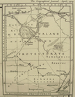
1929 Clifford - KALAHARI DESERT - Tribes - ROUTE MAP - Botswana.
£26.40
Condition:
- Buy it now1929 Clifford - KALAHARI DESERT - Tribes - ROUTE MAP - Botswana.
Oops! Looks like we're having trouble connecting to our server.
Refresh your browser window to try again.
Postage:
Located in: Monmouth, United Kingdom
Delivery:
Varies
Returns:
No returns accepted.
Payments:
Get more time to pay. See payment informationfor PayPal Credit - opens in a new window or tab
Shop with confidence
Seller assumes all responsibility for this listing.
eBay item number:264533128220
Item specifics
- Type
- Physical Map
- Year
- 1929
- Date Range
- 1920-1929
Item description from the seller
About this seller
rachel2919
100% positive Feedback•241 items sold
Registered as a private sellerThereby, consumer rights stemming from EU consumer protection law do not apply. eBay buyer protection still applies to most purchases.
Seller Feedback (117)
- b***c (8577)- Feedback left by buyer.Past yearVerified purchaseItems Received , Thank YouLego Atlantis Typhoon Turbo Sub (8060) 99% Complete With Box and Instructions (#264904021402)
- n***n (429)- Feedback left by buyer.More than a year agoVerified purchaseGood sellerRadley Small Hot Pink Cerise Shoulder Bag (#266704594384)
- r***6 (328)- Feedback left by buyer.More than a year agoVerified purchaseDelighted with this old Geo Journal and the specific article and map. All in great condition, well packaged and safe delivery. Top seller - well recommended!1931 Whitehouse LANGIA-ACHOLI MOUNTAINS, Sudan, Uganda, COLOUR MAP (#264719676432)
More to explore:
- 1920-1929 Antique Ordnance Survey Maps,
- 1920-1929 Date Range County Map Antique Folding Maps,
- 1920-1929 Date Range Sheet Map County Map Antique Maps, Atlases & Globes,
- 1920-1929 Date Range Antique Folding Maps,
- 1920-1929 Date Range Antique Physical Maps,
- 1920-1929 Date Range Antique Sheet Maps,
- 1920-1929 Date Range Ordnance Survey Map Antique Folding Maps,
- 1920-1929 Date Range Antique Railroad Maps,
- 1920-1929 Date Range City Map Antique Europe Folding Maps,
- 1920-1929 Date Range Ordnance Survey Map Antique Europe Folding Maps