
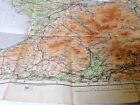
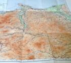
Ordnance Survey Cloth Map of Caernarvon and Bangor - 1930
£5.00£5.00
Sat, 26 Apr, 18:26Sat, 26 Apr, 18:26
Picture 1 of 6


Gallery
Picture 1 of 6


Ordnance Survey Cloth Map of Caernarvon and Bangor - 1930

£5.00
(£5.00 / Unit)
Condition:
“well preserved edition”
Good
A book that has been read, but is in good condition. Minimal damage to the book cover eg. scuff marks, but no holes or tears. If this is a hard cover, the dust jacket may be missing. Binding has minimal wear. The majority of pages are undamaged with some creasing or tearing, and pencil underlining of text, but this is minimal. No highlighting of text, no writing in the margins, and no missing pages. See the seller’s listing for full details and description of any imperfections.
Oops! Looks like we're having trouble connecting to our server.
Refresh your browser window to try again.
Postage:
Located in: Whitley Bay , Northumberland, United Kingdom
Delivery:
Varies
Returns:
30 days return. Buyer pays for return postage. If you use an eBay delivery label, it will be deducted from your refund amount.
Payments:
Get more time to pay. See payment informationfor PayPal Credit - opens in a new window or tab
Shop with confidence
Seller assumes all responsibility for this listing.
eBay item number:285750472356
Item specifics
- Condition
- Good
- Seller notes
- “well preserved edition”
- Bundesland
- Baden-Württemberg
- Publication Name
- Ordnance Survey
- Publisher
- Ordnance Survey
- City
- Caernarvon, Bangor
- Subject
- Road Map, Travel Routes
- Modified Item
- No
- Series
- Ordnance Survey
- Publication Year
- 1930
- Type
- Road Atlas
- Format
- Folding Map
- Language
- English
- Region
- England, Bath and Wells
- Country
- UK
- Map Scale
- 1:100,000
- Country/Region of Manufacture
- United Kingdom
Item description from the seller
Seller business information
CRN: 05741302
About this seller

Limelight Classic Books
100% positive Feedback•2.3K items sold
Registered as a business seller
Seller Feedback (1,029)
This item (1)
All items (1,029)
- m***i (977)- Feedback left by buyer.Past 6 monthsVerified purchaseJust a wonderful piece of history. As described and quick delivery. Thank you!
- _***_ (109)- Feedback left by buyer.Past monthVerified purchaseGreat item Well packaged As described in good condition Quick postage
- p***o (4526)- Feedback left by buyer.Past 6 monthsVerified purchaseAccurate description & prompt response. EXCELLENT transaction!
- n***d (288)- Feedback left by buyer.Past yearVerified purchaseItem exactly as described, prompt fast delivery. Excellent seller, I have absolutely nothing negative to say. 10/10 I will also add that the item was extremely well packaged to avoid any damage in transit. Excellent all round.The Case of Mary Bell by Gitta Sereny 1st Edition Hardback 1972 - AUTHOR signed (#285945101961)
More to explore:
- Ordnance Survey Hiking Maps,
- Ordnance Survey Maps & Atlases,
- Ordnance Survey Folding Map Maps & Atlases,
- Ordnance Survey Irish Maps & Atlases,
- Ordnance Survey European Maps & Atlases,
- Ordnance Survey English Maps & Atlases,
- Ordnance Survey 1st Edition Maps & Atlases,
- Ordnance Survey Wales Maps & Atlases in English,
- Ordnance Survey 1st Edition English Maps & Atlases,
- Ordnance Survey Atlas
Seller Feedback (1,029)
This item (1)
All items (1,029)
- m***i (977)- Feedback left by buyer.Past 6 monthsVerified purchaseJust a wonderful piece of history. As described and quick delivery. Thank you!
- _***_ (109)- Feedback left by buyer.Past monthVerified purchaseGreat item Well packaged As described in good condition Quick postage
- p***o (4526)- Feedback left by buyer.Past 6 monthsVerified purchaseAccurate description & prompt response. EXCELLENT transaction!
- n***d (288)- Feedback left by buyer.Past yearVerified purchaseItem exactly as described, prompt fast delivery. Excellent seller, I have absolutely nothing negative to say. 10/10 I will also add that the item was extremely well packaged to avoid any damage in transit. Excellent all round.The Case of Mary Bell by Gitta Sereny 1st Edition Hardback 1972 - AUTHOR signed (#285945101961)