Picture 1 of 6


Gallery
Picture 1 of 6


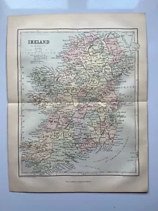
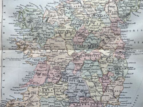
Antique map of Ireland 1876 Chambers's Encyclopedia
£12.00
Condition:
“Grubby marks and paper discolouration, centrefold”
- Buy it nowAntique map of Ireland 1876 Chambers's Encyclopedia
Oops! Looks like we're having trouble connecting to our server.
Refresh your browser window to try again.
Postage:
£4.20 Royal Mail International Standard.
Located in: Horncastle, United Kingdom
Delivery:
Estimated between Fri, 16 May and Fri, 30 May to 43230
Returns:
14 days return. Buyer pays for return postage. If you use an eBay delivery label, it will be deducted from your refund amount.
Payments:
Get more time to pay. See payment informationfor PayPal Credit - opens in a new window or tab
Shop with confidence
Seller assumes all responsibility for this listing.
eBay item number:297144870089
Item specifics
- Seller notes
- “Grubby marks and paper discolouration, centrefold”
- Antique
- Yes
- Date Range
- 1800-1899
- Type
- Political Map
- Format
- Atlas Map
- Printing Technique
- Lithography
- Year
- 1876
- Era
- 1800s
- Original/Reproduction
- Antique Original
- Country/Region
- Europe, Ireland
Item description from the seller
Seller business information
About this seller

Silicon Press
100% positive Feedback•2.2K items sold
Registered as a business seller
Popular categories from this shop
Seller Feedback (738)
- t***e (146)- Feedback left by buyer.Past 6 monthsVerified purchaseGreat Seller. A+. Fast shipping and courteous communication. Packaged expertly, the item arrived as described. All around Incredible value.Scotland antique map 1843 engraving (#296739016353)
- l***a (1564)- Feedback left by buyer.Past 6 monthsVerified purchaseThe prints arrived in excellent condition and were very well packaged. A five star seller. They were as described by the seller. Thank you!!Highland Tartan Macdonald antique chromolithograph 1875 (#296828516509)
- h***g (1094)- Feedback left by buyer.Past 6 monthsVerified purchaseAntique print received as described, promptly and well packed, thank you good seller!!!Richmond Railway Bridge, Surrey antique engraving 1852 (#296809956998)
More to explore:
- Ireland Marine & Maritime Antiques,
- Antique S & N Buck European Maps & Atlases,
- S & N Buck Antique Maps, Atlases & Globes,
- Antique Original County Map Antique Folding Maps,
- Antique Original Geological Map Antique Sheet Maps,
- Antique Original River Map Antique Sheet Maps,
- Antique Original County Map Antique Atlas Maps,
- Antique Original County Map Antique Wall Maps,
- Nautical Map Antique Folding Maps,
- City Map Antique Folding Maps
Popular categories from this shop
Seller Feedback (738)
- t***e (146)- Feedback left by buyer.Past 6 monthsVerified purchaseGreat Seller. A+. Fast shipping and courteous communication. Packaged expertly, the item arrived as described. All around Incredible value.Scotland antique map 1843 engraving (#296739016353)
- l***a (1564)- Feedback left by buyer.Past 6 monthsVerified purchaseThe prints arrived in excellent condition and were very well packaged. A five star seller. They were as described by the seller. Thank you!!Highland Tartan Macdonald antique chromolithograph 1875 (#296828516509)
- h***g (1094)- Feedback left by buyer.Past 6 monthsVerified purchaseAntique print received as described, promptly and well packed, thank you good seller!!!Richmond Railway Bridge, Surrey antique engraving 1852 (#296809956998)