Picture 1 of 4


Gallery
Picture 1 of 4


Have one to sell?
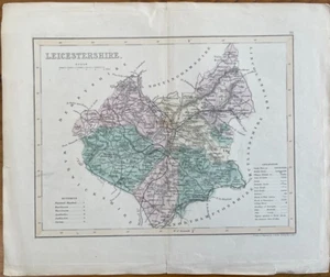
ANTIQUE MAP LEICESTERSHIRE C1850 BY J ARCHER HAND COLOURED
£9.06
or Best Offer
Condition:
- Buy it nowANTIQUE MAP LEICESTERSHIRE C1850 BY J ARCHER HAND COLOURED
Oops! Looks like we're having trouble connecting to our server.
Refresh your browser window to try again.
Postage:
Located in: Llanelli, United Kingdom
Delivery:
Varies
Returns:
No returns accepted.
Payments:
Get more time to pay. See payment informationfor PayPal Credit - opens in a new window or tab
Shop with confidence
Seller assumes all responsibility for this listing.
eBay item number:316106067172
Item specifics
- County
- Leicestershire
- Year
- 1850
- Antique
- Yes
- Type
- County Map
- Format
- Folding Map
- Printing Technique
- Lithography
- Era
- 1800s
- Original/Reproduction
- Antique Original
- Cartographer/Publisher
- J ARCHER
- Country/Region
- England
Item description from the seller
About this seller
dajo91010
100% positive Feedback•26 items sold
Registered as a private sellerThereby, consumer rights stemming from EU consumer protection law do not apply. eBay buyer protection still applies to most purchases.
Seller Feedback (18)
- h***s (500)- Feedback left by buyer.Past yearVerified purchaseBeautiful item better than described and a bargain price. Well packaged and protected and free delivery. An excellent eBay seller. Many thanksANTIQUE MAP OF YORKSHIRE C1790 BY JOHN SELLER, PUBLISHED BY FRANCIS GROSSE. (#316145175846)
- t***e (436)- Feedback left by buyer.Past yearVerified purchaseas described and sent promptlyANTIQUE MAP OF MONMOUTHSHIRE C1790 BY JOHN SELLER, PUBLISHED BY FRANCIS GROSSE. (#316035980092)
- h***c (1541)- Feedback left by buyer.Past 6 monthsVerified purchaseFantastic seller, great item, and a lovely guy, very knowledgeable. A pleasure to deal with, hope to do so again. Thank you.
More to explore:
- Leicestershire Antique Europe Topographical Maps,
- Antique European Maps & Atlases Leicestershire,
- Leicestershire Antique Europe Atlas Maps,
- Leicestershire Antique Europe Sheet Maps,
- Leicestershire Antique Europe County Maps,
- Leicestershire Antique Reproduction Antique Europe Sheet Maps,
- Leicestershire Wall Antique European Maps & Atlases,
- Leicestershire Ordnance Survey Map Antique Europe Sheet Maps,
- Leicestershire 1930-1939 Date Range Antique Europe Sheet Maps,
- Antique European Maps & Atlases Leicestershire 1800-1899 Date Range