Picture 1 of 3


Gallery
Picture 1 of 3


Have one to sell?
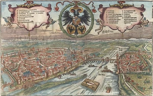
Map "Franckofordia

£350.00
or Best Offer
From £16.51 per month for 24 months with *
Condition:
- Buy it nowMap "Franckofordianae civitatis situs & figura" (Frankfurt) S. Munster, 1552
Oops! Looks like we're having trouble connecting to our server.
Refresh your browser window to try again.
Postage:
£18.00 International Tracked Postage.
Located in: London, United Kingdom
Delivery:
Estimated between Mon, 11 Aug and Fri, 15 Aug to 94104
Returns:
No returns accepted.
Payments:
*From £16.51 per month for 24 months.
Shop with confidence
Seller assumes all responsibility for this listing.
eBay item number:334954980322
Item specifics
- Format
- Sheet Map
- Era
- 1500s
- Printing Technique
- Woodcut
- Year
- 1552
- City
- Frankfurt
- Country/Region
- Germany
- Cartographer/Publisher
- Sebastian Munster
- Antique
- Yes
- Date Range
- 1500-1599
- Type
- County Map
- Original/Reproduction
- Antique Original
Item description from the seller
Seller business information
CRN: 07952137

Popular categories from this shop
Seller Feedback (303)
- e***2 (1298)- Feedback left by buyer.Past 6 monthsVerified purchaseExquisite 18th century depiction and gravure of the legendary Bastille by one of the greatest artists of the period and the engraver. Offered at a price point which was generous and more than affordable. This gravure was professionally, expertly packaged—which is a distinct pleasure. It is always pleasing to deal with a professional business in antiquities, as they possess the knowledge in handling fragile, irreplaceable, historical art. Sent securely by Fedex, arriving very quickly. Recommended
- f***5 (5)- Feedback left by buyer.Past 6 monthsVerified purchaseQuickly shipped, very well packaged with supporting internal card and plastic. As described and in good condition. Thank you once more. Comes once more with a certificate of authenticity, which is very much appreciated. This is my second map from this gallery and probably won't be the last. Highly recommended.Map "Southern Alps of New Zealand" Royal Geographical Society, 1910 (#334963326798)
- u***i (150)- Feedback left by buyer.Past 6 monthsVerified purchaseItem as described. Packed well with fast shipping. In good condition for its age! Would buy from this seller again.Antique Map "Carta delle Isole Pelew" (Palau/Philippines) Anon, c.1790 (#335166770898)
More to explore:
- Antique European Maps & Atlases Frankfurt,
- Frankfurt Antique Europe Sheet Maps,
- Frankfurt Antique Original Antique European Maps & Atlases,
- Antique European Maps & Atlases Frankfurt 1800-1899 Date Range,
- Antique S & N Buck European Maps & Atlases,
- S & N Buck Antique Maps, Atlases & Globes,
- Nautical Map Antique Folding Maps,
- Topographical Map Antique Sheet Maps,
- Topographical Map Antique Folding Maps,
- Physical Map Antique Folding Maps
Popular categories from this shop
Seller Feedback (303)
- e***2 (1298)- Feedback left by buyer.Past 6 monthsVerified purchaseExquisite 18th century depiction and gravure of the legendary Bastille by one of the greatest artists of the period and the engraver. Offered at a price point which was generous and more than affordable. This gravure was professionally, expertly packaged—which is a distinct pleasure. It is always pleasing to deal with a professional business in antiquities, as they possess the knowledge in handling fragile, irreplaceable, historical art. Sent securely by Fedex, arriving very quickly. Recommended
- f***5 (5)- Feedback left by buyer.Past 6 monthsVerified purchaseQuickly shipped, very well packaged with supporting internal card and plastic. As described and in good condition. Thank you once more. Comes once more with a certificate of authenticity, which is very much appreciated. This is my second map from this gallery and probably won't be the last. Highly recommended.Map "Southern Alps of New Zealand" Royal Geographical Society, 1910 (#334963326798)
- u***i (150)- Feedback left by buyer.Past 6 monthsVerified purchaseItem as described. Packed well with fast shipping. In good condition for its age! Would buy from this seller again.Antique Map "Carta delle Isole Pelew" (Palau/Philippines) Anon, c.1790 (#335166770898)