Picture 1 of 4


Picture 1 of 4


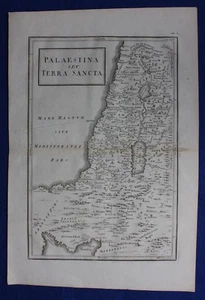
Original antique map HOLY LAND, 'PALAESTINA SEV TERRA SANCTA', Cellarius, 1799

£45.00
or Best Offer
Condition:
“Very good condition. Centrefold as published. Light age toning (darker along the centrefold). Crease ”... Read moreAbout condition
Postage:
£9.50 Royal Mail International Tracked.
Located in: Ilkley, United Kingdom
Delivery:
Estimated between Tue, 24 Sep and Sat, 28 Sep to 43230
Dispatched today if paid within 2 hrs 55 mins
Returns:
30 days return. Buyer pays for return postage.
Payments:
Get more time to pay. See payment informationfor PayPal Credit - opens in a new window or tab
Shop with confidence
Seller assumes all responsibility for this listing.
eBay item number:335338640525
Item specifics
- Seller notes
- Cartographer/Publisher
- C. Cellarius
- Printing Technique
- Copper Plate
- Date Range
- 1700-1799
- Original/Reproduction
- Antique Original
- Country/Region
- Palestine, Israel
- Era
- 1700s
- Format
- Atlas Map
- Type
- Atlas map
- Year
- 1799
Item description from the seller
Business seller information
Maps etc. Antique Maps & Prints
Tristan Wade
1 Brooklands Lane
Menston
Ilkley
West Yorkshire
LS29 6PL
United Kingdom
I certify that all my selling activities will comply with all EU laws and regulations.

Popular categories from this shop
Registered as a business seller
Seller Feedback (2,388)
- 0***e (904)- Feedback left by buyer.Past 6 monthsVerified purchasePleasant, reliable seller with good communication and customer service skills offers beautiful antique prints at reasonable prices. Print arrived very promptly and safely, carefully protected and packaged. Highest quality, very accurately described by seller. Perfect!Antique print BATAVIA, JAKARTA, INDONESIA, CHILDREN'S HOSPITAL , Churchill, 1744 (#333537419952)
- _***1 (262)- Feedback left by buyer.Past monthVerified purchaseCame well packaged and just as described. Excellent seller A*
- e***e (510)- Feedback left by buyer.Past 6 monthsVerified purchaseItem arrived promptly, very well packaged and as described. Thank you. 5* seller, highly recommended.IRELAND, ENNISCORTHY, TAGHMON, WEXFORD, antique road map, Taylor & Skinner, 1783 (#235508663447)
More to explore:
- Antique Original 1700-1799 Date Range Antique City Maps,
- Antique Original 1700-1799 Date Range Antique Atlas Maps,
- Antique Original 1700-1799 Date Range Antique Sheet Maps,
- Antique Original 1700-1799 Date Range Antique County Maps,
- Antique Original 1700-1799 Date Range Antique Europe Wall Maps,
- Antique Original 1700-1799 Date Range Antique Europe Political Maps,
- Antique Original 1700-1799 Date Range Antique Europe Sheet Maps,
- Antique Original 1700-1799 Date Range Antique Europe Atlas Maps,
- John Senex Antique Original Antique Maps, Atlases & Globes 1700-1799 Date Range,
- Antique Original Geological Map Antique Sheet Maps