
Picture 1 of 4


Gallery
Picture 1 of 4


Have one to sell?
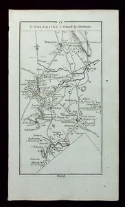
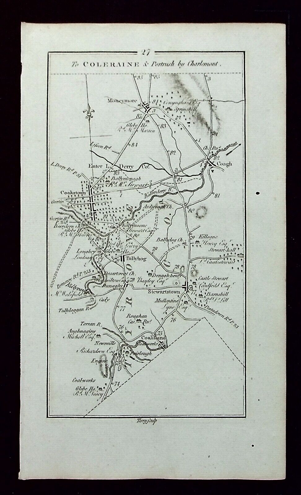
ULSTER, COOKSTOWN, MAGHERAFELT, antique road map, Taylor & Skinner, 1783

£25.50
Condition:
“Very good condition. Light age toning. Two small, marginal wormholes, not affecting the printed ”... Read moreAbout condition
- Buy it nowULSTER, COOKSTOWN, MAGHERAFELT, antique road map, Taylor & Skinner, 1783
Oops! Looks like we're having trouble connecting to our server.
Refresh your browser window to try again.
Postage:
£9.50 Royal Mail International Tracked.
Located in: Ilkley, United Kingdom
Delivery:
Estimated between Mon, 28 Jul and Tue, 5 Aug to 94104
Returns:
30 days return. Buyer pays for return postage. If you use an eBay delivery label, it will be deducted from your refund amount.
Payments:
Get more time to pay. See payment informationfor PayPal Credit - opens in a new window or tab
Shop with confidence
Seller assumes all responsibility for this listing.
eBay item number:335838499205
Item specifics
- Seller notes
- Antique
- Yes
- Date Range
- 1700-1799
- Type
- Antique road map
- Printing Technique
- Copper Plate
- Format
- Atlas Map
- Year
- 1783
- Era
- 1700s
- Cartographer/Publisher
- Taylor & Skinner
- Original/Reproduction
- Antique Original
- Country/Region
- Ireland
- County
- Londonderry, Tyrone
Item description from the seller
Seller business information
About this seller

Maps etc. Antique Maps & Prints
100% positive Feedback•5.6K items sold
Registered as a business seller
Seller Feedback (2,522)
- e***a (70)- Feedback left by buyer.Past 6 monthsVerified purchaseI am giving this purchase a 5-star rating, even though the map arrived more than a month late & the shipping tube had been severely mangled (no damage to the contents). Neither problem was the Seller's fault. The shipment was held by US Customs for a month (visible on the tracking documents) without explanation or contact. Seller remained in regular contact, offered to, and then refunded full purchase price during this hiatus. Upon successful delivery, Seller re-invoiced for the map, & I paid.Original antique atlas map BRITISH ISLES, GREAT BRITAIN, IRELAND, E Bowen, 1747 (#335916077525)
- 1***1 (698)- Feedback left by buyer.Past monthVerified purchaseReceived very quickly and well packaged. Item as described, excellent seller.
- r***o (2729)- Feedback left by buyer.Past yearVerified purchaseGreat Seller - This map arrived exactly as described it will be a great addition for my Ancestry research. The map arrived very well packaged and rolled carefully and placed into a postal tube. The delivery was well within the estimated time. I would have no hesitation in recommending this seller to any potential buyers - THANK YOU.PLYMOUTH, DEVONPORT, CITY PLAN, STREET PLAN, original antique map, Bacon, 1884 (#235500514934)
More to explore:
- Road Atlas Antique Folding Maps,
- Antique Original Road Atlas Antique Folding Maps,
- Road Atlas Antique Europe Atlas Maps,
- Road Atlas Antique Europe Sheet Maps,
- Road Atlas Antique Europe Folding Maps,
- Road Atlas Vintage Original Antique Europe Folding Maps,
- Antique Original River Map Antique Sheet Maps,
- Antique Original County Map Antique Wall Maps,
- Antique Road Atlas,
- Nautical Map Antique Folding Maps
Maps etc. Antique Maps & Prints
100% positive Feedback•5.6K items sold
Registered as a business seller
Seller Feedback (2,522)
- e***a (70)- Feedback left by buyer.Past 6 monthsVerified purchaseI am giving this purchase a 5-star rating, even though the map arrived more than a month late & the shipping tube had been severely mangled (no damage to the contents). Neither problem was the Seller's fault. The shipment was held by US Customs for a month (visible on the tracking documents) without explanation or contact. Seller remained in regular contact, offered to, and then refunded full purchase price during this hiatus. Upon successful delivery, Seller re-invoiced for the map, & I paid.Original antique atlas map BRITISH ISLES, GREAT BRITAIN, IRELAND, E Bowen, 1747 (#335916077525)
- 1***1 (698)- Feedback left by buyer.Past monthVerified purchaseReceived very quickly and well packaged. Item as described, excellent seller.
- r***o (2729)- Feedback left by buyer.Past yearVerified purchaseGreat Seller - This map arrived exactly as described it will be a great addition for my Ancestry research. The map arrived very well packaged and rolled carefully and placed into a postal tube. The delivery was well within the estimated time. I would have no hesitation in recommending this seller to any potential buyers - THANK YOU.PLYMOUTH, DEVONPORT, CITY PLAN, STREET PLAN, original antique map, Bacon, 1884 (#235500514934)