Picture 1 of 2

Gallery
Picture 1 of 2


Have one to sell?
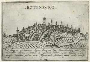
Map "Rothenburg ob der Tauber" (Germany) Francesco Valegio-D. Rascicotti, c.1598

£180.00
or Best Offer
From £16.01 per month for 12 months with *
Condition:
- Buy it nowMap "Rothenburg ob der Tauber" (Germany) Francesco Valegio-D. Rascicotti, c.1598
Oops! Looks like we're having trouble connecting to our server.
Refresh your browser window to try again.
Postage:
£18.00 Royal Mail International Tracked.
Located in: London, United Kingdom
Delivery:
Estimated between Fri, 8 Aug and Wed, 13 Aug to 94104
Returns:
No returns accepted.
Payments:
*From £16.01 per month for 12 months.
Shop with confidence
Seller assumes all responsibility for this listing.
eBay item number:336013180281
Item specifics
- Antique
- Yes
- Date Range
- 1500-1599
- Type
- City Map
- Format
- Sheet Map
- Printing Technique
- Copper Plate
- Year
- 1598
- Era
- 1500s
- State
- Bavaria
- Cartographer/Publisher
- Francesco Valegio - Donato Rascicotti
- Original/Reproduction
- Antique Original
- City
- Rothenburg ob der Tauber
- Country/Region
- Germany
Item description from the seller
Seller business information
CRN: 07952137

Popular categories from this shop
Seller Feedback (303)
- e***2 (1298)- Feedback left by buyer.Past 6 monthsVerified purchaseExquisite 18th century depiction and gravure of the legendary Bastille by one of the greatest artists of the period and the engraver. Offered at a price point which was generous and more than affordable. This gravure was professionally, expertly packaged—which is a distinct pleasure. It is always pleasing to deal with a professional business in antiquities, as they possess the knowledge in handling fragile, irreplaceable, historical art. Sent securely by Fedex, arriving very quickly. Recommended
- f***5 (5)- Feedback left by buyer.Past 6 monthsVerified purchaseQuickly shipped, very well packaged with supporting internal card and plastic. As described and in good condition. Thank you once more. Comes once more with a certificate of authenticity, which is very much appreciated. This is my second map from this gallery and probably won't be the last. Highly recommended.Map "Southern Alps of New Zealand" Royal Geographical Society, 1910 (#334963326798)
- u***i (150)- Feedback left by buyer.Past 6 monthsVerified purchaseItem as described. Packed well with fast shipping. In good condition for its age! Would buy from this seller again.Antique Map "Carta delle Isole Pelew" (Palau/Philippines) Anon, c.1790 (#335166770898)
More to explore:
- Germany Marine & Maritime Antiques,
- Germany Sextant Marine & Maritime Antiques,
- Germany WWII Marine & Maritime Antiques,
- Germany Clock Marine & Maritime Antiques,
- Germany Brass Marine & Maritime Antiques,
- Nautical Map Antique Folding Maps,
- Topographical Map Antique Folding Maps,
- Nautical Map Antique Sheet Maps,
- Geological Map Antique Folding Maps,
- Physical Map Antique Atlas Maps
Popular categories from this shop
Seller Feedback (303)
- e***2 (1298)- Feedback left by buyer.Past 6 monthsVerified purchaseExquisite 18th century depiction and gravure of the legendary Bastille by one of the greatest artists of the period and the engraver. Offered at a price point which was generous and more than affordable. This gravure was professionally, expertly packaged—which is a distinct pleasure. It is always pleasing to deal with a professional business in antiquities, as they possess the knowledge in handling fragile, irreplaceable, historical art. Sent securely by Fedex, arriving very quickly. Recommended
- f***5 (5)- Feedback left by buyer.Past 6 monthsVerified purchaseQuickly shipped, very well packaged with supporting internal card and plastic. As described and in good condition. Thank you once more. Comes once more with a certificate of authenticity, which is very much appreciated. This is my second map from this gallery and probably won't be the last. Highly recommended.Map "Southern Alps of New Zealand" Royal Geographical Society, 1910 (#334963326798)
- u***i (150)- Feedback left by buyer.Past 6 monthsVerified purchaseItem as described. Packed well with fast shipping. In good condition for its age! Would buy from this seller again.Antique Map "Carta delle Isole Pelew" (Palau/Philippines) Anon, c.1790 (#335166770898)