Picture 1 of 2


Picture 1 of 2
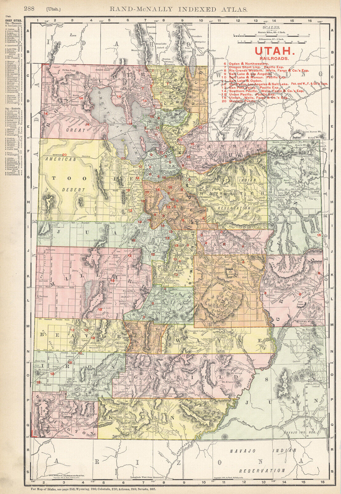
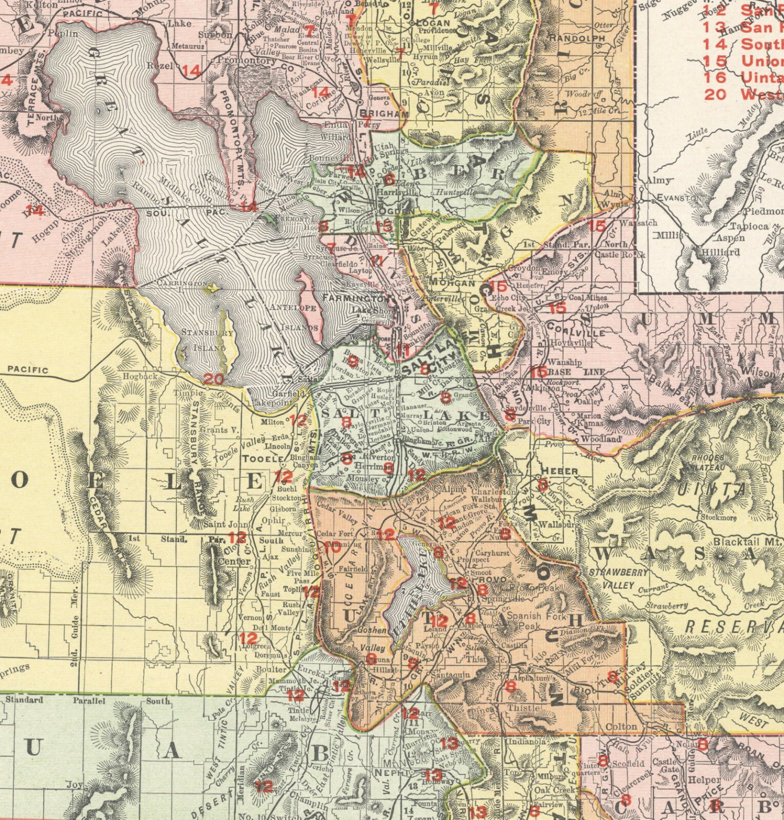
1908 UTAH Railroads

US $16.50
Approximately£12.45
Condition:
“VG.”
Postage:
US $2.75 (approx £2.08) USPS First Class®.
Located in: San Diego, California, United States
Delivery:
Estimated between Fri, 27 Sep and Wed, 2 Oct to 43230
Returns:
14 days return. Buyer pays for return postage.
Payments:
Shop with confidence
Seller assumes all responsibility for this listing.
eBay item number:352985532000
Item specifics
- Seller notes
- “VG.”
- Cartographer/Publisher
- Rand McNally & Co.
- Printing Technique
- Lithography
- Original/Reproduction
- Antique Original
- Format
- Atlas Map
- Type
- Physical Map
- Year
- 1864
- US State
- Dakotas, AR, IA, KS, LA, MO, NE, Utah
- Date Range
- 1900-1909
- Country/Region
- United States of America
Item description from the seller
Business seller information
Pacific Shore Maps
Richard Cloward
, CA
United States
I certify that all my selling activities will comply with all EU laws and regulations.
![Pacific Shore [Collectible] Maps](https://i.ebayimg.com/images/g/ti0AAOSwdIZdwbZo/s-l140.jpg)
Registered as a business seller
Seller Feedback (3,116)
- 4***5 (226)- Feedback left by buyer.Past yearVerified purchaseThank you Nice selection Excellent packaging and shipping Easiest of transaction Excellent communication Very nice people Will be back soon1857 Colton's "Greece and the Ionian Republic (#352985522404)
- f***f (1304)- Feedback left by buyer.Past yearVerified purchaseVery nice item, exactly as described and pictured, super fast shipping, perfect packing. Thanks.1860 USPRR lithograph: Hudson's Bay Mill-WASHINGTON (#374654218030)
- o***r (266)- Feedback left by buyer.Past 6 monthsVerified purchaseI really appreciate the great communication and look forward to purchasing from you again !1884 Steiler Map: Central USA: Indian Territory, Missouri, Arkansas, Texas (#354101892451)
More to explore:
- Antique North American Maps & Atlases Utah,
- Utah Antique North America City Maps,
- Antique Railroad Maps,
- Utah Antique Original Antique North America Maps & Atlases,
- Antique Europe Railroad Maps,
- Antique World Railroad Maps,
- Antique Original Antique Railroad Maps,
- Railroad Map Antique Europe Folding Maps,
- Missouri Antique North America Railroad Maps,
- 1920-1929 Date Range Antique World Railroad Maps