Picture 1 of 3


Gallery
Picture 1 of 3


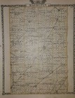
Old 1876 Map CARROLLTON Twp., GREENE Co., ILLINOIS / MACOUPIN Co. on Reverse
US $45.12
Approximately£33.94
or Best Offer
Was US $48.00 (6% off)
Condition:
“Always Quick N Free S&H ~ Reasonable offers are always considered. Browse through over 3500 Rare, ”... Read moreAbout condition
- Buy it nowOld 1876 Map CARROLLTON Twp., GREENE Co., ILLINOIS / MACOUPIN Co. on Reverse
Oops! Looks like we're having trouble connecting to our server.
Refresh your browser window to try again.
Postage:
Free USPS Ground Advantage®.
Located in: San Antonio, Texas, United States
Delivery:
Estimated between Wed, 14 May and Tue, 20 May to 43230
Returns:
30 days return. Buyer pays for return postage. If you use an eBay delivery label, it will be deducted from your refund amount.
Payments:
Shop with confidence
Seller assumes all responsibility for this listing.
eBay item number:355063172316
Item specifics
- Seller notes
- Cartographer/Publisher
- Warner & Beers - Union Atlas Co.
- Original/Reproduction
- Antique Original
- Format
- Atlas Map
- Ref#
- ILLINOIS-W&BEERS1876/021522
- Authentic
- Authentic map printed in 1876.
- Type
- County Map
- Year
- 1876
- US State
- United States, IL, IN, MI, OH, WI, Illinois
- City
- Carlinville
- Date Range
- 1800-1899
- Country/Region
- United States of America
Item description from the seller
About this seller

MapHatter
99.7% positive Feedback•27K items sold
Registered as a private sellerThereby, consumer rights stemming from EU consumer protection law do not apply. eBay buyer protection still applies to most purchases.
Seller Feedback (9,517)
- n***d (88)- Feedback left by buyer.Past 6 monthsVerified purchaseExtraordinary piece of history, fast shipping,great packaging, as described, affordable prices. Outstanding seller. 10k recommended.
- r***c (132)- Feedback left by buyer.Past monthVerified purchaseItem was packaged well and delivered as described. Quick shipping and good communication from seller. A+ transaction. Thank you!
- r***5 (6011)- Feedback left by buyer.Past 6 monthsVerified purchaseNice map at a fair price, accurately described. A seller I have previously bought from before and will buy from in the future. Packaged well, shipped fast and free!1871 Plat Map ~ ROCKTON Twp., BELOIT CITY, WINNEBAGO Co., ILLINOIS ~(15x17)-#010 (#405400075912)
More to explore:
- Illinois Antique North America Wall Maps,
- Illinois Antique North America County Maps,
- Antique North American Maps & Atlases Illinois,
- Illinois Antique North America City Maps,
- Illinois Antique Original Antique North America Maps & Atlases,
- Elkington & Co. Antique Silver-Plated Cutlery,
- Tiffany & Co. Antique Silver Cutlery Sets,
- Tiffany & Co. 1900-1940 Antique Silver,
- George F. Cram Co. Antique World Globes & Celestial Globes,
- Old School Desk
MapHatter
99.7% positive Feedback•27K items sold
Registered as a private sellerThereby, consumer rights stemming from EU consumer protection law do not apply. eBay buyer protection still applies to most purchases.
Seller Feedback (9,517)
- n***d (88)- Feedback left by buyer.Past 6 monthsVerified purchaseExtraordinary piece of history, fast shipping,great packaging, as described, affordable prices. Outstanding seller. 10k recommended.
- r***c (132)- Feedback left by buyer.Past monthVerified purchaseItem was packaged well and delivered as described. Quick shipping and good communication from seller. A+ transaction. Thank you!
- r***5 (6011)- Feedback left by buyer.Past 6 monthsVerified purchaseNice map at a fair price, accurately described. A seller I have previously bought from before and will buy from in the future. Packaged well, shipped fast and free!1871 Plat Map ~ ROCKTON Twp., BELOIT CITY, WINNEBAGO Co., ILLINOIS ~(15x17)-#010 (#405400075912)