
Picture 1 of 1
Picture 1 of 1

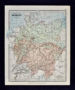
1889 Hughes Map - Physical Germany Bavaria Alps Danube Austria Baltic Sea Europe

US $9.99
Approximately£7.86
or Best Offer
Was US $12.49 (20% off)
Condition:
“Very Good, on a page measuring 7 1/4 by 8 1/2" (18x22cm), see the pic and description below.”
Ended: 19 May, 2024 06:36:35 BST
Postage:
Located in: Fairview, Pennsylvania, United States
Delivery:
Estimated between Mon, 3 Jun and Wed, 5 Jun to 43230
Returns:
Payments:
Shop with confidence
Seller assumes all responsibility for this listing.
eBay item number:364305870483
Item specifics
- Seller notes
- “Very Good, on a page measuring 7 1/4 by 8 1/2" (18x22cm), see the pic and description below.”
- Original/Reproduction
- Antique Original
- Country/Region
- Germany
- City
- Munich
- Date Range
- 1800-1899
- Type
- Physical Map
- Format
- Atlas Map
- Year
- 1889
- Cartographer/Publisher
- Hughes
Item description from the seller
Seller assumes all responsibility for this listing.
eBay item number:364305870483
Post to me
| Free P&P on orders of 5 or more eligible items from c574778. |
| Free P&P on each additional eligible item you buy from c574778. |
Item location:
Fairview, Pennsylvania, United States
Posts to:
Afghanistan, Albania, Algeria, American Samoa, Andorra, Angola, Anguilla, Antigua and Barbuda, Argentina, Armenia, Aruba, Australia, Austria, Azerbaijan Republic, Bahamas, Bahrain, Bangladesh, Belarus, Belgium, Belize, Benin, Bermuda, Bhutan, Bolivia, Bosnia and Herzegovina, Botswana, Brazil, British Virgin Islands, Brunei Darussalam, Bulgaria, Burkina Faso, Burundi, Cambodia, Cameroon, Canada, Cape Verde Islands, Cayman Islands, Central African Republic, Chad, Chile, China, Colombia, Comoros, Cook Islands, Costa Rica, Cyprus, Czech Republic, Côte d'Ivoire (Ivory Coast), Democratic Republic of the Congo, Denmark, Djibouti, Dominica, Dominican Republic, Ecuador, Egypt, El Salvador, Equatorial Guinea, Eritrea, Estonia, Ethiopia, Falkland Islands (Islas Malvinas), Fiji, Finland, France, Gabon Republic, Gambia, Georgia, Germany, Ghana, Gibraltar, Greece, Greenland, Grenada, Guam, Guatemala, Guernsey, Guinea, Guinea-Bissau, Guyana, Haiti, Honduras, Hong Kong, Hungary, Iceland, India, Indonesia, Iraq, Ireland, Israel, Italy, Jamaica, Japan, Jersey, Jordan, Kazakhstan, Kenya, Kiribati, Kuwait, Kyrgyzstan, Laos, Latvia, Lebanon, Lesotho, Liberia, Liechtenstein, Lithuania, Luxembourg, Macau, Macedonia, Madagascar, Malawi, Malaysia, Maldives, Mali, Malta, Marshall Islands, Mauritania, Mauritius, Mayotte, Mexico, Micronesia, Moldova, Monaco, Mongolia, Montenegro, Montserrat, Morocco, Mozambique, Namibia, Nauru, Nepal, Netherlands, Netherlands Antilles, New Zealand, Nicaragua, Niger, Nigeria, Niue, Norway, Oman, Pakistan, Palau, Panama, Papua New Guinea, Paraguay, Peru, Philippines, Poland, Portugal, Puerto Rico, Qatar, Republic of Croatia, Republic of the Congo, Romania, Rwanda, Saint Helena, Saint Kitts-Nevis, Saint Lucia, Saint Pierre and Miquelon, Saint Vincent and the Grenadines, San Marino, Saudi Arabia, Senegal, Serbia, Seychelles, Sierra Leone, Singapore, Slovakia, Slovenia, Solomon Islands, Somalia, South Africa, South Korea, Spain, Sri Lanka, Suriname, Svalbard and Jan Mayen, Swaziland, Sweden, Switzerland, Taiwan, Tajikistan, Tanzania, Thailand, Togo, Tonga, Trinidad and Tobago, Tunisia, Turkey, Turkmenistan, Turks and Caicos Islands, Tuvalu, Uganda, United Arab Emirates, United Kingdom, Uruguay, Uzbekistan, Vanuatu, Vatican City State, Vietnam, Virgin Islands (U.S.), Wallis and Futuna, Western Sahara, Western Samoa, Worldwide, Yemen, Zambia, Zimbabwe
Excludes:
Barbados, French Guiana, French Polynesia, Guadeloupe, Libya, Martinique, New Caledonia, Reunion, Russian Federation, Ukraine, Venezuela
| Postage and packaging | To | Service | Delivery*See Delivery notes |
|---|---|---|---|
| US $4.99 (approx £3.92) | United States | Standard Delivery (USPS Ground Advantage®) | Estimated between Mon, 3 Jun and Wed, 5 Jun to 43230 |
| US $8.99 (approx £7.07) | United States | Expedited Delivery (USPS Priority Mail®) | Estimated between Mon, 3 Jun and Wed, 5 Jun to 43230 |
| Dispatch time |
|---|
| Will usually dispatch within 1 working day of receiving cleared payment. |
| Taxes |
|---|
| Taxes may be applicable at checkout. Learn moreLearn more about paying tax on eBay purchases. |
Returns policy
| After receiving the item, cancel the purchase within | Refund will be given as | Return postage |
|---|---|---|
| 30 days | Money back | Seller pays for return postage |
Refer to eBay return policyopens in a new tab or window for more details. You're covered by the eBay Money Back Guaranteeopens in a new tab or window if you receive an item that is not as described in the listing.
The seller is responsible for return postage costs.
| Return policy details |
|---|
| Returns accepted |
Most purchases from business sellers are protected by the Consumer Contract Regulations 2013 which give you the right to cancel the purchase within 14 days after the day you receive the item. Find out more about your rights as a buyer and exceptions.
Payment details
Payment methods

More to explore:
- Antique Europe Physical Maps,
- Bavaria Antique Europe Sheet Maps,
- Bavaria Antique Europe Atlas Maps,
- Physical Map Antique Europe Atlas Maps,
- Physical Map Antique Europe Sheet Maps,
- Lithography Antique Europe Physical Maps,
- Antique Physical Maps,
- Antique Asia Physical Maps,
- Antique Africa Physical Maps,
- Antique World Physical Maps