
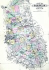
1900 Stuart Map Maine Franklin County Wilton Farmington Rangeley Jay Bridge ME
US $39.98US $39.98
Wed, 20 Aug, 03:27Wed, 20 Aug, 03:27
Picture 1 of 4


Gallery
Picture 1 of 4


1900 Stuart Map Maine Franklin County Wilton Farmington Rangeley Jay Bridge ME

US $39.98
Approximately£30.04
Was US $49.98 (20% off)
Condition:
“Good to Very Good condition with light tonal ageing with a centerfold as issued. There are a few ”... Read moreAbout condition
Ended: 20 Aug, 2025 03:27:27 BST
Oops! Looks like we're having trouble connecting to our server.
Refresh your browser window to try again.
Postage:
US $4.99 (approx £3.75) USPS Ground Advantage®.
Located in: Fairview, Pennsylvania, United States
Delivery:
Estimated between Sat, 1 Nov and Fri, 7 Nov
Returns:
30 days return. Seller pays for return postage.
Payments:
Shop with confidence
Seller assumes all responsibility for this listing.
eBay item number:365380453936
Item specifics
- Seller notes
- Date Range
- 1900-1909
- Type
- County Map
- Format
- Atlas Map
- US State
- CT, MA, ME, NH, RI, VT, Maine
- Year
- 1900
- Original/Reproduction
- Antique Original
- Cartographer/Publisher
- J.H. Stuart
- City
- Augusta
- Country/Region
- United States of America
Item description from the seller
Seller business information
About this seller

Lake Erie Antique Maps and Prints
99.8% positive Feedback•40K items sold
Registered as a business seller
Seller Feedback (20,025)
This item (1)
All items (20,025)
- 6***i (788)- Feedback left by buyer.Past monthVerified purchaseGreat transaction. Very pleased.
- 1***m (15)- Feedback left by buyer.Past 6 monthsVerified purchaseVendor good to deal with, second or third time I have bought from them. Item as descried and in good condition Safely packed Delivery time good. Recommend vendor1869 Bartholomew Map Queensland Cape York Melville Brisbane Cairns Australia (#405337580929)
- x***u (161)- Feedback left by buyer.Past 6 monthsVerified purchaseMy second order from this seller. As before, the shipping was fast and the map was well packed and protected. Included with the original map was a photocopy of the title page of the book the map came from. Definitely one of my favorite sellers!1836 Gordon Map Syracuse Salina City Plan Mill Pond Salt Company Oswego Canal NY (#365563445498)
- 6***7 (57)- Feedback left by buyer.Past monthVerified purchaseToday I have received this large map with provenance pages. packaging is good condition.the map is same as shown picture online .it's worth it's valuable .thank you for sharing.
More to explore:
- Maine Antique North America County Maps,
- 1900-1909 Date Range Antique County Maps,
- 1900-1909 Date Range County Map Antique Europe Atlas Maps,
- 1900-1909 Date Range County Map Antique Europe Folding Maps,
- 1900-1909 Date Range County Map Antique Europe Sheet Maps,
- Antique County Maps,
- London 1900-1909 Date Range Antique Europe County Maps,
- County Map Antique Europe Atlas Maps,
- Copper Plate 1900-1909 Date Range Antique Europe County Maps,
- Northumberland Antique County Maps
Lake Erie Antique Maps and Prints
99.8% positive Feedback•40K items sold
Registered as a business seller
Seller Feedback (20,025)
This item (1)
All items (20,025)
- 6***i (788)- Feedback left by buyer.Past monthVerified purchaseGreat transaction. Very pleased.
- 1***m (15)- Feedback left by buyer.Past 6 monthsVerified purchaseVendor good to deal with, second or third time I have bought from them. Item as descried and in good condition Safely packed Delivery time good. Recommend vendor1869 Bartholomew Map Queensland Cape York Melville Brisbane Cairns Australia (#405337580929)
- x***u (161)- Feedback left by buyer.Past 6 monthsVerified purchaseMy second order from this seller. As before, the shipping was fast and the map was well packed and protected. Included with the original map was a photocopy of the title page of the book the map came from. Definitely one of my favorite sellers!1836 Gordon Map Syracuse Salina City Plan Mill Pond Salt Company Oswego Canal NY (#365563445498)
- 6***7 (57)- Feedback left by buyer.Past monthVerified purchaseToday I have received this large map with provenance pages. packaging is good condition.the map is same as shown picture online .it's worth it's valuable .thank you for sharing.