
Picture 1 of 8


Gallery
Picture 1 of 8


Have one to sell?
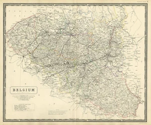
Antique Map-Belgium and Luxembourg-Nat
£139.50
or Best Offer
From £12.41 per month for 12 months with *
Condition:
“Very good, given age. Small margins, central fold. General age-related toning and/or occasional ”... Read moreAbout condition
- Buy it nowAntique Map-Belgium and Luxembourg-National Atlas-Johnston-ca. 1880
Oops! Looks like we're having trouble connecting to our server.
Refresh your browser window to try again.
Postage:
Doesn't post to United States.
Located in: Zeeland, Netherlands
Delivery:
Varies
Returns:
30 days return. Buyer pays for return postage. If you use an eBay delivery label, it will be deducted from your refund amount.
Payments:
*From £12.41 per month for 12 months.
Shop with confidence
Seller assumes all responsibility for this listing.
eBay item number:375881156033
Item specifics
- Seller notes
- Country/Region
- Belgium
- City
- Not applicable
- Date Range
- 1800-1899
- Original/Reproduction
- Antique Original
- Type
- Topographical Map
- Format
- Atlas Map
- Cartographer/Publisher
- William & Alexander Keith Johnston
- Printing Technique
- Copper Plate
- Year
- 1880
- Subject
- Maps
- Publisher
- William & Alexander Keith Johnston
- Medium
- Engraving
- Framing
- Unframed
- Signed
- Plate signed
- Color
- Multi-Color
- Size
- Medium
- Orientation
- Landscape
- Height (Inches)
- 21.0
- Width (Inches)
- 25.6
- Height (Centimeters)
- 53.3
- Width (Centimeters)
- 65.0
Item description from the seller
Seller business information
VAT number: NL 820763196B01
CRN: 17248592
About this seller
ThePrintsCollector UK Antique Maps
100% positive Feedback•3.8K items sold
Registered as a business seller
Popular categories from this shop
Seller Feedback (1,691)
- r***r (200)- Feedback left by buyer.Past monthVerified purchaseEl artículo es tal cual se describe, el embalaje perfecto, el envío sin problemas. Muy satisfecho, una compra perfecta…
- 9***3 (1322)- Feedback left by buyer.Past 6 monthsVerified purchaseArtikel sehr gut und sicher verpackt! Sehr schneller Versand! Zustand wie beschrieben!!!Antique Map-HAAKSBERGEN-BOEKELO-HOLTHUIZEN-TOWN PLAN-OVERIJSSEL-Kuyper-1865 (#374809108459)
- a***j (481)- Feedback left by buyer.Past 6 monthsVerified purchaseEverything was perfect! Fast delivery, well-packaged. +++ Recommended seller +++ANTIQUE MAP-NETHERLANDS-TOWN PLAN-ZOUTELANDE-ZEELAND-Kuyper-Kuijper-1865 (#375963337087)
More to explore:
- Keith Johnston Antique Atlas Maps,
- Keith Johnston Antique Europe Atlas Maps,
- Alexander K. Johnston Antique Atlas Maps,
- Keith Johnston Antique Asia Atlas Maps,
- Alexander K. Johnston Antique Africa Atlas Maps,
- Alexander K. Johnston Antique Asia Atlas Maps,
- Alexander K. Johnston Antique Australia/Oceania Atlas Maps,
- City Map Antique Atlas Maps,
- Topographical Map Antique Atlas Maps,
- Physical Map Antique Atlas Maps