Picture 1 of 2

Gallery
Picture 1 of 2

Have one to sell?
London Street Maps 1863 (Stanfords Libra... by Edward Stanford Sheet map, folded
FREE US DELIVERY | ISBN: 1873590644 | Quality Books

US $32.50
Approximately£24.06
Condition:
Very Good
A book that has been read and does not look new, but is in excellent condition. No obvious damage to the book cover, with the dust jacket (if applicable) included for hard covers. No missing or damaged pages, no creases or tears, no underlining or highlighting of text, and no writing in the margins. Some identifying marks on the inside cover, but this is minimal. Very little wear and tear. See the seller’s listing for full details and description of any imperfections.
3 available6 sold
- Buy it nowLondon Street Maps 1863 (Stanfords Libra... by Edward Stanford Sheet map, folded
Oops! Looks like we're having trouble connecting to our server.
Refresh your browser window to try again.
Postage:
Free USPS Ground Advantage®.
Located in: Florida, United States
Delivery:
Estimated between Tue, 5 Aug and Tue, 12 Aug to 94104
Returns:
30 days return. Buyer pays for return postage. If you use an eBay delivery label, it will be deducted from your refund amount.
Payments:
Shop with confidence
Seller assumes all responsibility for this listing.
eBay item number:382883917380
Item specifics
- Condition
- ISBN
- 1873590644
- EAN
- 9781873590645
- Date of Publication
- 2007-01-01
- Publication Name
- N/A
- Type
- Sheet map, folded
- Release Title
- London Street Maps 1863
- Artist
- Edward Stanford
- Brand
- N/A
- Colour
- N/A
About this product
Product Identifiers
Publisher
Bloomsbury Publishing
ISBN-10
1873590644
ISBN-13
9781873590645
eBay Product ID (ePID)
72074256
Product Key Features
Topic
Europe / Great Britain
Book Title
London 1863
Publication Year
2009
Language
English
Genre
Travel
Format
Quantity Pack
Dimensions
Item Length
38.9 in
Item Width
27 in
Additional Product Features
Intended Audience
Trade
Synopsis
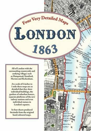
At a scale of 6 inches to 1 mile, these maps show individual buildings, the gardens of suburban houses, separate platforms of the railway stations and even individual statues in London's squares., This work features 4 sheets at a very detailed scale of six inches to the mile. The massive expansion of the Victorian age produced a demand for detailed maps to determine ownership of land and to plan development. Edward Stanford, a leading Victorian cartographer, produced these maps to show the railways, factories, docks and roads that were springing up everywhere. So detailed are these maps that even individual gardens of suburban homes are shown as are separate platforms of the new railway termini and, astonishingly, even the individual statues in the city's squares. Anyone seeking information about their forebears will be able to see the roads, alleyways and outlying villages where they lived; where they went to school; the pubs where they spent their meagre wages; the churches and chapels where they were married and where they attended Sunday services; the factories, docks and farms where they worked; also maybe the miserable workhouses where they ended their days and the burial grounds where they were laid to rest. Local historians will find fields separating Hampstead and Kilburn with just the occasional farm; footpaths wandering through open country between Peckham and Dulwich. Closer to the centre, the main activity in Parsons Green is market gardening and in Kentish Town there was a vast slaughterhouse, with separate sections for sheep and cattle, close to the suitably named Butcher's Arms public house. Factories for making calico, lead shot, turpentine and candles as well as distilleries and breweries are marked and along the river are docks and factories for timber, flour and all the commodities newly arrived from the rapidly growing empire. Large houses, just one deep, face onto Clapham Common with farmland at the end of their large gardens. Numerous prisons, asylums and orphanages are shown as well as institutions such as The Soldiers Daughter's Home, The Aged Governess Asylum and a Female Reformatory. The early railways are marked as are the houses of famous people such as Sir Rowland Hill the social reformer who invented the postal service. Noticing what is marked is often as fascinating as seeing what has not yet been developed and together they provide a fascinating glimpse of Mid Victorian London.
Item description from the seller
Seller business information
VAT number: GB 922696893
About this seller

World of Books USA
86.5% positive Feedback•5.2M items sold
Registered as a business seller
Seller Feedback (1,557,664)
- n***d (49)- Feedback left by buyer.Past 6 monthsVerified purchaseExcellent seller. Package was delayed ( by bad weather) and then misplaced at PO( placed in wrong box #) but I contacted the seller and they responded quickly and I got my item today. This seller went the extra mile and I would highly recommend them and will shop here again. I also want to say the price for this complete hard to find item was way below most of the other listings. Condition was good as stated, and although I've only watched the first disc it's quality is good. Thank you!!Tenko : Complete BBC Series Box Set [DVD] - DVD EQVG The Cheap Fast Free Post (#306002146201)
- r***d (273)- Feedback left by buyer.Past monthVerified purchaseItem in great condition 😁 SELLER communicated any time I had a question 😍 Good value 😊 packaged securely 🙂 Shipping said 7-14 days which is correct , would purchase again from rhis seller ... Thank You
- 6***t (479)- Feedback left by buyer.Past monthVerified purchasePurchasing form this company can at times be frustrating due to items never arriving, very low shipping time and the inability to track the items. But I gave them another chance and purchased many maps and books over the past few months and have received all of them. Last year, it was hit and miss. All items were in the condition as described. Packaging is minimal. The only downside is extremely slow shipping. I rate them a C+. Nothing to gloat about but eventually you will get what you wanted.
More to explore:
- London Folding Map Maps & Atlases,
- Sheet and Folded Maps for European Region,
- Sheet and Folded Maps for UK Region,
- Cycling Maps Folding Maps,
- City Maps Folding Maps,
- Folding Map Maps & Atlases,
- French Maps & Atlases Folding Maps,
- India Folding Map Maps & Atlases,
- African Maps & Atlases Folding Maps,
- Scotland Folding Map Maps & Atlases in English
Seller Feedback (1,557,664)
- n***d (49)- Feedback left by buyer.Past 6 monthsVerified purchaseExcellent seller. Package was delayed ( by bad weather) and then misplaced at PO( placed in wrong box #) but I contacted the seller and they responded quickly and I got my item today. This seller went the extra mile and I would highly recommend them and will shop here again. I also want to say the price for this complete hard to find item was way below most of the other listings. Condition was good as stated, and although I've only watched the first disc it's quality is good. Thank you!!Tenko : Complete BBC Series Box Set [DVD] - DVD EQVG The Cheap Fast Free Post (#306002146201)
- r***d (273)- Feedback left by buyer.Past monthVerified purchaseItem in great condition 😁 SELLER communicated any time I had a question 😍 Good value 😊 packaged securely 🙂 Shipping said 7-14 days which is correct , would purchase again from rhis seller ... Thank You
- 6***t (479)- Feedback left by buyer.Past monthVerified purchasePurchasing form this company can at times be frustrating due to items never arriving, very low shipping time and the inability to track the items. But I gave them another chance and purchased many maps and books over the past few months and have received all of them. Last year, it was hit and miss. All items were in the condition as described. Packaging is minimal. The only downside is extremely slow shipping. I rate them a C+. Nothing to gloat about but eventually you will get what you wanted.