Picture 1 of 7


Gallery
Picture 1 of 7


Have one to sell?
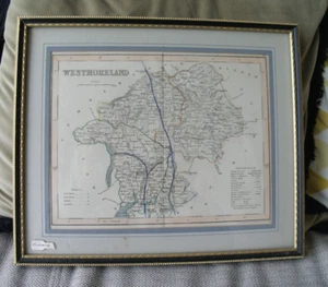
ANTIQUE FRAMED MAP WESTMORELAND CUMBRIA DRAWN & ENGRAVED BY J.ARCHER PENTONVILLE
£21.22
or Best Offer
Condition:
“Good vintage condition.”
- Buy it nowANTIQUE FRAMED MAP WESTMORELAND CUMBRIA DRAWN & ENGRAVED BY J.ARCHER PENTONVILLE
Oops! Looks like we're having trouble connecting to our server.
Refresh your browser window to try again.
Postage:
Doesn't post to United States.
Located in: LANGFORD, BEDS, United Kingdom
Delivery:
Varies
Returns:
No returns accepted.
Payments:
Get more time to pay. See payment informationfor PayPal Credit - opens in a new window or tab
Shop with confidence
Seller assumes all responsibility for this listing.
eBay item number:395444055188
Item specifics
- Seller notes
- “Good vintage condition.”
- Antique
- Yes
- Date Range
- 1800-1899
- Type
- County Map
- Format
- Atlas Map
- Year
- 1850
- Era
- 1800s
- Original/Reproduction
- Antique Original
- Cartographer/Publisher
- J. Archer
- Country/Region
- United Kingdom
- County
- Cumbria, Westmorland
Item description from the seller
About this seller
susie-q10
100% positive Feedback•6.3K items sold
Registered as a private sellerThereby, consumer rights stemming from EU consumer protection law do not apply. eBay buyer protection still applies to most purchases.
Seller Feedback (3,491)
- j***s (32)- Feedback left by buyer.Past 6 monthsVerified purchaseArrived well packed, item as described. Recommend this seller
- r***n (252)- Feedback left by buyer.Past 6 monthsVerified purchaseLovely wee pot, as described, brilliantly packaged,fast delivery,great price. 10/10 thanks
- d***t (235)- Feedback left by buyer.Past 6 monthsVerified purchaseArrived well packed and in good condition, as described . Good communication. Thank you.HEAVY CUT GLASS HATCHED DIAMOND DESIGN SHIPS DECANTER AND 6x RUMMERS GLASSES (#396322248656)
More to explore:
- Antique European Maps & Atlases Cumbria,
- Cumbria Antique Europe Folding Maps,
- Cumbria Antique Europe County Maps,
- Cumbria Antique Europe Sheet Maps,
- Cumbria Antique Original Antique Europe Sheet Maps,
- Cumbria Antique Europe Ordnance Survey Maps,
- Cumbria Antique Original Antique European Maps & Atlases,
- Manuscript/Hand drawn Antique Maps, Atlases & Globes,
- Antique European Maps & Atlases Cumbria 1600-1699 Date Range,
- Antique Original County Map Antique Folding Maps