Picture 1 of 10


Gallery
Picture 1 of 10


Have one to sell?
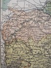
Irish Map Co DOWN Belfast Newcastle Northern Ireland Color PW Joyce 1905 7x9.5

US $33.00
Approximately£24.43
Condition:
“Vintage map from a damaged atlas/history of Ireland published in 1905, in good condition. See ”... Read moreAbout condition
- Buy it nowIrish Map Co DOWN Belfast Newcastle Northern Ireland Color PW Joyce 1905 7x9.5
Oops! Looks like we're having trouble connecting to our server.
Refresh your browser window to try again.
Postage:
Free USPS Media MailTM.
Located in: West Yellowstone, Montana, United States
Delivery:
Estimated between Wed, 30 Jul and Wed, 6 Aug to 94104
Returns:
60 days return. Buyer pays for return postage. If you use an eBay delivery label, it will be deducted from your refund amount.
Payments:
Shop with confidence
Seller assumes all responsibility for this listing.
eBay item number:401334322346
Item specifics
- Seller notes
- County
- Antrim, Down
- Cartographer/Publisher
- P.W. Joyce
- Printing Technique
- Lithography
- Original/Reproduction
- Original as published
- Maker
- Murphy & McCarthy
- Topic
- Ireland
- Publication Year
- 1905
- Format
- Atlas Map
- Map View
- Down Northern Ireland
- Continent
- Europe
- Era
- 1900s
- Type
- County Map
- Modified Item
- No
- Personalized
- No
- Year
- 1905
- City
- Belfast
- Date Range
- 1900-1909
- Country/Region
- Northern Ireland, Ireland
Item description from the seller
About this seller

Montana Gael
99.6% positive Feedback•12K items sold
Registered as a private sellerThereby, consumer rights stemming from EU consumer protection law do not apply. eBay buyer protection still applies to most purchases.
Seller Feedback (6,635)
- i***i (69)- Feedback left by buyer.Past 6 monthsVerified purchaseMontanaGael was excellent seller to buy from. Amazing communication & fast shipping! Antique Irish Postcards are as described, packaged beautifully & stunning quality! I will cherish them forever.
- p***y (404)- Feedback left by buyer.Past 6 monthsVerified purchaseItem as described and in great condition. Great communication. Prompt delivery. Excellent packing. I highly recommend this seller. A+++Irish PC KENMARE Kerry IRELAND Multiview Town Old Bridge Sheen Falls Penman 404 (#404999593480)
- t***a (1416)- Feedback left by buyer.Past 6 monthsVerified purchaseA really good as described 100-year-old postcard photographed and published by my grandfather Robert Runyon. A very good seller who works with you, packs well and ships quickly.Vintage Postcard UN JACAL MEXICANO Mexican Home Thatch & Wood Robert Runyon (#276307556733)
More to explore:
- Northern Hemisphere Antique World Maps & Atlases,
- Antique European Maps & Atlases Down,
- Down Antique Europe Sheet Maps,
- Down Ordnance Survey Map Antique Europe Sheet Maps,
- Northern Territory Antique Australia/Oceania Maps & Atlases,
- Northern Hemisphere Antique World Maps & Atlases 1800-1899 Date Range,
- Ireland Marine & Maritime Antiques,
- Nautical Map Antique Folding Maps,
- City Map Antique Sheet Maps,
- Geological Map Antique Atlas Maps
Montana Gael
99.6% positive Feedback•12K items sold
Registered as a private sellerThereby, consumer rights stemming from EU consumer protection law do not apply. eBay buyer protection still applies to most purchases.
Seller Feedback (6,635)
- i***i (69)- Feedback left by buyer.Past 6 monthsVerified purchaseMontanaGael was excellent seller to buy from. Amazing communication & fast shipping! Antique Irish Postcards are as described, packaged beautifully & stunning quality! I will cherish them forever.
- p***y (404)- Feedback left by buyer.Past 6 monthsVerified purchaseItem as described and in great condition. Great communication. Prompt delivery. Excellent packing. I highly recommend this seller. A+++Irish PC KENMARE Kerry IRELAND Multiview Town Old Bridge Sheen Falls Penman 404 (#404999593480)
- t***a (1416)- Feedback left by buyer.Past 6 monthsVerified purchaseA really good as described 100-year-old postcard photographed and published by my grandfather Robert Runyon. A very good seller who works with you, packs well and ships quickly.Vintage Postcard UN JACAL MEXICANO Mexican Home Thatch & Wood Robert Runyon (#276307556733)